UNCED Part 1
World Status of Desertification
A. CONCEPT OF DESERTIFICATION
1. The concept of desertification was defined
by UNCOD in 1977 as follows:
"Desertification is the diminution or
destruction of the biological
potential of land, and can lead
ultimately to desert-like conditions.
It is an aspect of the widespread
deterioration of ecosystems, and has
diminished or destroyed the biological
potential, i.e. plant and animal production,
for multiple use purposes at a time
when increased productivity is needed to
support growing populations
in quest of development."
2. This definition was found inadequate
and not sufficiently operational
when attempts started in different parts
of the world to implement various
practical recommendations of the PACD and
to undertake the quantitative
assessment of desertification. A series of
definitions was developed by
individual scientists, scientific
institutions and implementing agencies. A
more precise new definition was required,
particularly in view of the need
to distinguish between desertification
and another phenomenon of observed
cyclic oscillations of vegetation
productivity at desert fringes (desert
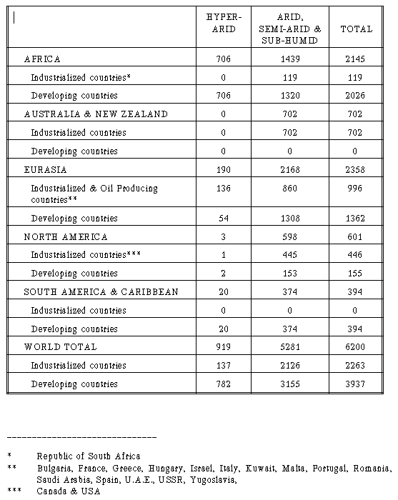
expansion or contraction) as revealed
by satellite data and related to climate
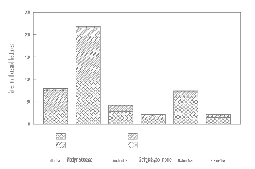
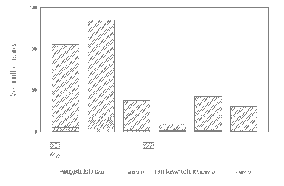
fluctuations.
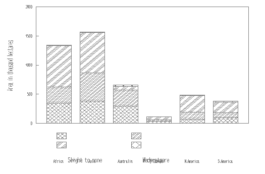
3. Based on special studies and
extensive discussions at the Ad-Hoc
Consultative Meeting on the Assessment
of Desertification, which was convened
by UNEP in Nairobi in February 1990,
the following definition of desertification
was adopted:
"Desertification/Land Degradation,
in the context of assessment, is Land
Degradation in Arid, Semi-arid and
Dry Sub-humid Areas resulting from
adverse human impact.
Land in this concept includes
soil and local water resources, land
surface and vegetation or crops.
Degradation implies reduction
of resource potential by one or a
combination of processes acting
on the land. These processes include water
erosion, wind erosion and sedimentation
by those agents, long term
reduction in the amount or diversity
of natural vegetation, where
relevant, and salinization and sodication."
4. The last definition was used by UNEP
for the quantitative assessment
of the status of desertification which
was conducted during 1990-1991. The
important point is not the exact
wording of the definition of desertification
but an agreement on a more operationally
suitable tool for assessing and
combating the problem. This
definition sets desertification within the
broad frame of global land degradation.
5. The Panel of Senior Consultants,
convened by UNEP in Geneva from 25 to
27 April 1991, to discuss the first
draft of a revised PACD, considered the
desertification concept as well. It
was pointed out that the new document
should more clearly spell out the
likely impacts of natural climatic
conditions, particularly of recurrent
droughts, on desertification; it
would be necessary to note that
in certain instances desertification might not
only be human-induced but climate-induced as well.
6. The Governing Council of UNEP,
at its 16th session in May 1991, also
considered this question. By its
decision 16/22, it underlined the need for
further refinement of the definition
of the concept of desertification, taking
into account recent findings about the
influence of climate fluctuations and
about the resilience of soils.
7. As a follow-up to the above
considerations and taking into account the
results of additional studies and
consultation undertaken by UNEP, the following
definition was finally adopted for
the present assessment of the status of
desertification and preparations for UNCED:
"Desertification is land
degradation in arid, semi-arid and dry
sub-humid areas resulting mainly
from adverse human impact."
8. Further refinement of the
concept and the definition of desertification
taking into account possible influence of
climate fluctuations and soil resilience,
as indicated by the Governing Council of
UNEP, may be undertaken in future on the
basis of new knowledge acquired in the
course of detailed area-specific studies
and assessments. However, the present
gaps in knowledge do not provide an excuse
for delaying the implementation of the
PACD as the existing data give overwhelming
justification for a need to act urgently
and effectively to control the ongoing
land degradation in areas affected.
9. The urgency to address the
problem of desertification by co-ordinated
international action is accentuated
by the facts that:
• the time for action is running
short as desertification
expands threatening new areas
and new societies, while
anti-desertification measures
tend to be long-term and time demanding;
• the cost of anti-desertification
measures escalates from year to
year because (a) the area affected
is growing (b) the degree of the
damage is growing, and (c) world
prices and costs of rehabilitative
measures are growing;
• off-site (and social)
costs of desertification will continue to
increase as degradation adversely
affects land, water and air
resources;
• other environmental and
economic problems are increasing, tending
to distract the attention of society
to other urgent needs;
• if the process of
desertification is not arrested in the near
future, world shortage of food
will increase dramatically within a few
decades.
10. Whether the process of desertification
or its end result is considered,
the most obvious symptoms relate to:
• reduction of yield or crop
failure in irrigated or rainfed farmland;
• reduction of perennial
plant cover and biomass produced by rangeland
and consequent depletion of food available to livestock;
• reduction of available
woody biomass and consequent extension of
distance to sources of fuelwood or building material;
• reduction of available water
due to a decrease of river flow or
groundwater resources;
• encroachment of sand that may
overwhelm productive land, settlements
or infrastructures;
• increased flooding,
sedimentation of water bodies, water and air
pollution;
• societal disruption due to
deterioration of life-support systems,
societal need for outside help (relief
aid) or for seeking haven
elsewhere (environmental refugees).
11. The causes of these various
forms of ecological degradation and
corresponding socio-economic disruption
relate to a combination of (a) human
exploitation that oversteps the natural
carrying capacity of the land resource
system and sometimes increased negligence
and abandonment of land due to the
out-migration of people, (b) inherent
ecological fragility of the
resource system, and (c) adverse climatic
conditions, in particular, severe
recurrent droughts. The high degree of
land degradation plays a large part in
increasing the susceptibility of farming
systems to the shocks of drought, as
was so clearly seen in the Sudano-Sahelian
region of Africa during the last
three decades. Land resource exploitation
acts through land-use operations,
among which are : irrigated farming,
rainfed agriculture and pastoralism, with a
certain contribution from wood cutting,
extraction of mineral resources,
excessive tourism and hunting game
animals, etc. Excessive human pressures on
natural resource systems relate to :
(1) increase of population and escalation
of human needs; (2) socio-political
processes that bring pressures on rural
communities for orienting their production
towards national and international
markets; (3) socio-economic processes that
reduce the market value of rural
products and escalate the prices of
basic needs of rural people; (4) processes
of national development, especially
programmes for expansion of farmlands for
production of cash crops, that exacerbate
conflicts of land and water use and
often reduce areas available to marginalized
communities. An overriding
socio-economic issue in desertification is
the imbalance of power and access
to strategic resources between different
groups in the society.
12. Desertification is a very
distinctive global environmental and
socio-economic problem requiring special
attention. This process is singled out
under the specific term of desertification
and distinguished from similar
phenomena in other more humid areas of the
world because it proceeds under harsh
climatic conditions and acts adversely on
areas with limited natural
resources, i.e. soil, water and vegetation.
Naturally, there are extents and
degrees, but the end result of degraded and
abandoned land is a question of
time only, if the process is not arrested.
13. The urgency to address this
problem is connected with the fact that
desertification:
Socio-economically:
• constitutes the main cause
and mechanism of global loss of productive
land resources and thus reduces the world
capability of providing
sufficient food and shelter to growing
populations, contributing to the
spread of poverty and hunger;
• causes economic instability
and political unrest in areas affected,
struggle for scarce land and water
resources, outward migration in seek of
relief and refuge;
• brings pressures on the
economy and stability of societies outside
areas affected by desertification
through escalating need for food aid,
growth of environmental refugees, etc.;
• prevents achievement
of sustainable development in countries and
regions affected and through them,
the world as a whole;
• directly threatens health
and nutrition status of populations
menaced, particularly children.
Environmentally:
• is one element of planetary
environment degradation that contributes
to climate change, water, air and soil
pollution, deforestation, soil loss,
etc.;
• contributes to loss of
global biodiversity, particularly in the areas
which are the centres of origin of major
crop species of the world, e.g.
wheat, barley, sorghum, maize, etc.;
• contributes to loss of biomass
and bioproductivity of the planet and
to the exhaustion of global humus reserve,
thus disrupting normal global
biogeo-chemical turnover and reducing
the global carbon dioxide sink in
particular;
• contributes to global climate
change by increasing land surface
albedo, increasing potential, and
decreasing actual evapotranspiration
rate, changing the ground surface
energy budget and adjoining air
temperature, and adding dust and
CO2 into the atmosphere.
14. Desertification is always a
site-specific problem that occurs locally
within state boundaries and affects
local societies of sovereign states.
Therefore, it can only be solved by
the peoples themselves. Governments and
peoples of localities and countries
affected are the primary actors of the
anti-desertification campaign. At the
same time, as a global problem,
desertification needs to be addressed
by internationally co-ordinated efforts
because:
• it is a problem of
global magnitude with major environmental and
socio-economic consequences;
• the problem is complex and
requires a holistic integrated approach
including social, economic, political
and technical measures which can only
be provided by concerted and co-ordinated
efforts of the world community;
• countries most seriously
affected by desertification usually are
developing countries including least
developed ones, which do not have the
means of coping with a problem of such magnitude;
• the problem of desertification,
most seriously and directly, affects
rural areas and populations engaged
in various agricultural activities;
however, world-wide agriculture needs
substantial subsidies to survive and
to feed the world; without additional
support it would be virtually
impossible to cope with the requirements
of combating desertification and
the related activities of reclaiming drylands.
B. PAST ASSESSMENTS
(I) ASSESSMENT BY UNCOD, 1977
15. The following key indicative figures,
based on various studies
conducted in different parts of the world by
individuals, scientific
institutions and relevant agencies, both
within and outside the United Nations
system, were provided to UNCOD:
• According to soil/vegetation data,
world drylands constitute 6.45 billion hectares
or 43 percent of global land. According
to climatic data,world drylands
constitutes 5.55 billion hectares
or 37 percent of global land.
• Area threatened at least
moderately by desertification within
the drylands 3.97 billion hectares
or 75.1 per cent of the total drylands,
excluding hyper-arid deserts
• Countries affected by desertification > 100
• Inhabitants of the world
drylands > 15% of the worlds population
• Population in areas recently
undergoing severe desertification 78.5
million
• Annual rate of land degradation
(in arid and semi arid areas only)
in million hectares:
|
Irrigated lands
|
0.125
|
|
Rainfed croplands
|
2.500
|
|
Rangelands
|
3.200
|
|
TOTAL
|
5.825
|
• Annual loss of productive capacity
(income foregone) US$ 26 billion
• Annual cost of land reclamation measures
US$ 388 million
• Annual benefit of land reclamation measures
US$ 895 million
• A twenty-year worldwide programme
to arrest further desertification
requires about US$ 4.5 billion a year
or US$ 90 billion in total, of which
developing countries in need of
financial assistance would require US$ 2.4
billion a year or US$ 48 billion for twenty years.
16. Calculations on the basis of maps
produced by FAO, UNESCO and WMO for
the conference showed the following
areas of dryland in the world in million
hectares: Table
17. Territories affected by
desertification hazard were assessed by UNCOD
as follows:
|
RISK
|
ARID
|
SEMI-ARID
|
SUB-HUMID
|
WORLD TOTAL
|
|
|
*
|
**
|
*
|
**
|
*
|
**
|
*
|
**
|
|
Very severe |
110 |
6.7 |
220 |
11.5 |
20 |
5.0 |
350 |
8.8 |
|
Severe |
1340 |
80.7 |
440 |
23.1 |
60 |
15.0 |
1840 |
46.4 |
|
Moderate |
210 |
12.6 |
1250 |
65.4 |
320 |
80.0 |
1780 |
44.8 |
|
World Total |
1660 |
100.0 |
1910 |
100.0 |
400 |
100.0 |
3970 |
100.0 |
|
________________
* million hectares
** % of the affected area
|
(II) ASSESSMENT BY UNEP, 1984
18. The general assessment of t
he status and trend of desertification was undertaken by
UNEP in accordance with UNEPs Governing Council
decision 9/22A of 26 May 1981. The
summarized results of the assessment were
presented in the Executive Directors Report UNEP
GC.12/9 of 16 February 1984 and were considered
by the Governing Council at its 12th
Session. The main findings arising from the
assessment showed that:
• the scale and urgency of the
problem of desertification as presented to UNCOD
and addressed by the PACD were confirmed;
• desertification has continued
to spread and intensify despite efforts undertaken
since 1977, and the efforts were too modest to be effective;
• land degraded to desert-like
conditions continued at 6 million hectares annually,
and land reduced to zero or negative net
economic productivity was showing an
increase (from 20 to 21 million hectares annually);
• areas affected by at least
moderate desertification were: 3,100 million hectares
of rangelands, 335 million hectares of
rainfed croplands, and 40 million hectares
of irrigated lands, thus totalling up to
3,475 million hectares;
• rural populations in areas
severely affected by desertification numbered 135
million;
• projections to the year 2000
indicated that desertification in rangelands would
continue to increase at existing rates; in rainfed
croplands it would accelerate into
a critical situation; in irrigated lands,
the status of desertification would likely
remain largely as it was, with gains balancing
losses and with possible local
improvements;
• the cost of losses due to
desertification was estimated as five times the cost of
halting desertification.
19. Areas within arid, semi-arid and
sub-humid zones of the worlds drylands were estimated
as follows:
|
AFFECTED BY
DESERTIFICATION
|
NOT AFFECTED BY
DESERTIFICATION |
TOTAL |
|
|
million
hectares |
%* |
million
hectares |
%* |
million
hectares |
%* |
|
Rangelands** |
3100 |
80 |
600 |
20 |
3700 |
100 |
|
Rainfed croplands |
335 |
60 |
235 |
40 |
570 |
100 |
|
Irrigated lands |
40 |
30 |
91 |
70 |
131 |
100 |
|
Total |
3475 |
70 |
926 |
30 |
4409 |
100 |
|
______________________
* % of their total areas in
drylands
** The term rangelands, for
purposes of desertification assessment,
includes all territories presently
used as grazing lands, which are accounted
for in yearly FAOs statistics,
as well as other non-agricultural,
largely unoccupied, drylands which are
used only occasionally by nomadic
pastoralists or are presently unused at
all. |
C. PRESENT STATUS - ASSESSMENT 1991
20. A new assessment of the world
status of desertification was undertaken by
UNEP in 1990-1991 in accordance with the
provisions of UN General Assemblys
Resolution 44/172 of December 1989.
(I) DEFINITION OF DRYLAND AREA
21. For purposes of the present assessment
a new working definition of
desertification was adopted in February
1990 (see para. 3 above). Following
this definition, a world map of drylands was
prepared by GEMS/GRID of UNEP in
1991, on the basis of climatic data sets supplied
by the University of East
Anglia for the period of1951-1980. Aridity
zones were defined in accordance
with their physical parameters using the
following precipitation over potential
evapotranspiration (calculated by adapted
Thornthwaite formula as opposed to
the Penman formula used in 1977) ratios:
|
Hyper-arid
|
0.05
|
|
Arid
|
0.05-0.20
|
|
Semi-arid
|
0.21-0.50
|
|
Dry sub-humid
|
0.51-0.65
|
|
Moist sub-humid & Humid
|
0.65
|
|
______________________
For the region boundaries the
conventions used in the Times
Atlas of the World,1985 were
followed.
|
WORLD DRYLANDS
22. According to these new data, the following
is the area of world drylands
in million hectares:
|
|
Africa |
Asia |
Australia |
Europe |
North
America |
South
America |
World Total |
%
|
|
Hyper-arid |
672 |
277 |
0 |
0 |
3 |
26 |
978 |
16 |
|
Arid |
504 |
626 |
303 |
11 |
82 |
45 |
1571} |
|
Semi-arid |
514 |
693 |
309 |
105 |
419 |
265 |
2305} 5172 |
84 |
|
Dry Sub-humid |
269 |
353 |
51 |
184 |
232 |
207 |
1296} |
|
Total |
1959 |
1949 |
663 |
300 |
736 |
543 |
6150 |
100 |
|
% |
32 |
32 |
11 |
5 |
12 |
8 |
100 |
23. The estimates of the total area
of the world drylands made in 1977, 1984
and 1991 were obtained using slightly
different methodologies and different
climatic data sets. Therefore, they
should not be compared as a time-sequence.
The latest (1991) data sets are regarded
as more precise being based on
time-dependent climatic data selected
with most rigorous criteria. A
remarkable coincidence of estimates
of total drylands of the world in 1977 and
1991 should be noted, while the
differences between the continental figures are
sometimes significant. Thus, all figures
given above and below should be
regarded as indicative only, with a degree
of accuracy of + 10%.
24. It follows from the above that
accurate measurement of changes in areas
of lands affected by desertification
during 1977-1991 at global or continental
scales is not attainable as the observed
changes will fall within the range of
standard error. However, estimations
of changes and trends are possible for
areas where more precise data are available
as a result of recent detailed
assessments at national or local level.
(II)GLOBAL STATUS OF DESERTIFICATION
(a) Socio-economic aspects
25. During the whole period under
consideration, from 1978 to 1991, and even
earlier during recent decades, while people
were the main agents of
desertification, they were also its victims.
Throughout the world drylands in
developing countries, desertification
has been one of the main factors in the
migration of subsistence farmers and
pastoralists to the slums and shanty towns
of major cities looking for better opportunities,
producing desperate
populations vulnerable to disease and natural
disasters and prone to participate
in crime and civil strife. Such exodus from
rural to urban areas has
exacerbated the already dire urban problems
in many developing countries
affected by desertification. At the
same time, it has delayed efforts to
rehabilitate and develop dryland rural
areas through lack of manpower and
increased negligence of land. The
effects of land degradation in drylands were
compounded by recurrent severe droughts.
26. The mass exodus from rural areas
affected by desertification that has
been taking place in Africa since the
late 1970s is a vivid illustration of the
plight of people facing such intolerable
environmental conditions. At the peak
of the crisis, in 1984 and 1985, an
estimated 30-35 million people in 21 African
countries were seriously affected by severe
droughts, of which about 10 million
were displaced and became known as
environmental refugees. Death, disease,
chronic malnutrition and disability haunt
these millions of refugees because of
continuing intolerable living conditions.
In 1991 there were still some 30
million Africans who were threatened
by famine and needed urgent external food
aid in order to survive, e.g. Angola,
Ethiopia, Mozambique, Somalia, The Sudan
and several countries in West Sahel.
27. Recent developments further
underlined the fact that desertification is
the result of complex interactions
between physical, chemical, biological,
socio-economic and political issues,
both of local, national and global nature.
It was often overlooked that challenges
to productivity and thus the physical,
chemical and biological stability of
land were closely linked to national
and international economic policies.
The socio-economic climate and thus the
political framework of land tenure,
taxation and trade barriers have been
particularly disadvantageous for poor
developing countries affected by, or prone
to, desertification during the past decades.
The burden placed on the
individual land user in these
countries can partly be traced to international
policies and markets, but also have roots
in transition in local usufruct rights
and in domestic priorities, often
favoring the urban consumer over the rural
producer, and political and economic
mismanagement in developing countries
themselves. Development policies
often lacked poverty abatement orientation, so
that marginalized peoples often got
little support in breaking the vicious
circles that forced them to mismanage
land. Women land users often failed to
obtain credit and access to advisory
services that could improve their land use
practices.
28. Most developing countries
affected by desertification today
not only face
high population growth rates
(frequently 3.0-3.5% per annum)
but also high rates
of urbanization (8-10% per annum).
Some countries in Latin America already have
3/4 of their population living in towns and
cities, with Asia and Africa just
above 1/3 and under 1/3, respectively.
There are countries in Africa with more
than half of the population urbanized, e.g.
Zambia 52%, Djibouti 81%. The
growing number of urban dwellers requires
food. There is therefore a steady
stream of soil nutrients (in the form
of food, fuelwood and charcoal) moving
from the productive countryside to the
towns, to end up as useless, often
polluting, sewage. This rapid
transition from rural to urban societies has not
been matched by equally rapid replenishment
of soil nutrients, as was
so characteristic of the older subsistence
economies in developing countries or
of modernized agriculture in developed ones.
29. Demand on production has increased
the pressure on existing productive
land and moved the limits of production
onto increasingly marginal lands. There
is a steady tendency of expansion of
irrigation onto rainfed croplands while the
latter is encroaching onto better rangelands
forcing pastoralists to move
further onto poorer and dryer desert
areas of lower productivity. This process
is accompanied by an ever increasing rate
of soil degradation as marginal lands
are much more susceptible to adverse
processes like erosion and salinization.
Increased use of the worlds drylands
for cropping and grazing means increased
dependence on rainfed agriculture and
rangelands, where rainfall not only is low
but highly variable. A run of dry years,
as experienced throughout the drylands
in seventies and eighties, followed periods
of favorable rainfall when cropping
and high stocking rates become common in
areas previously little used. As
desertification persisted, productivity
fell but food demands grew with growing
populations. Famine persisted. Although
the drylands have shown remarkable
resilience, returning more rapidly
to productive states with subsequent wetter
years than was expected by most experts,
they remain vulnerable and will
doubtlessly be subject to new
droughts and famines.
30. Agricultural expansion to
marginal lands often resulted in rapid land
degradation, with subsequent decline in
production. With marginal drylands, it
is often hunger for land that causes
agricultural encroachment by poor
marginalized farmers, and it illustrates
that unwise use of land is also a
poverty issue. Unless adequate livelihoods
can be created elsewhere, e.g.
through further intensification of agriculture
in fertile areas or the creation
of off-farm employment, there is little
political realism in trying to stop
agricultural encroachment on marginal
drylands and consequently,
desertification.
31. The overall situation in areas
affected by desertification, particularly
in Africa, may be illustrated by a
conclusion of the most recent study in The
Sudan (K. Olsson and A. Rapp, 1991):
The drought of 1982-1984 resulted in
serious dryland degradation in Central
Sudan (Kordofan). The period was
characterized by greatly diminished
rainfall, loss of vegetation, crop failures
with zero harvest of cereals, soil
erosion, famine, suffering and death of
people and livestock,and human migration
from the region. The northward
movement of grassland that occurred
following the culmination of the drought of
1982-1984 appears to represent a quite rapid
recovery from drought-engendered
dryland degradation. Recovery can be
attributed, in part, to an increase in
rainfall, but it is important to
note that rainfall during the period 1985-
1987 remained below the long-term
average for the region. Thus it seems that
an important contributor to the
recovery has been the low level
of exploitation
during the period 1985-1986,
owing to the large numbers of people and animals
that had been wiped out during
1983-1984.
(b) State of the land
32. Two global data sets showing
different aspects of dryland deterioration
were obtained in the course of the present assessment.
The first data set was produced in
ICASALS of Texas Tech University, USA, on
the basis of available country
statistics with reference to major land uses in
drylands. It shows various forms of
land degradation in drylands delineated in
previous assessments with a correction
for subdividing the sub-humid zone into
two parts, dry and moist.
The second one relates to soil
degradation within drylands of the world
delineated by the GEMS/GRID aridity
zones and is based on the World Map of the
Status of Human Induced Soil Degradation
(GLASOD) prepared by ISRIC/UNEP in 1990
at an average scale of 1:10,000,000.
Due to scale limitations, this map shows
the situation only by continents with
no relation to major land-use systems.
The two data sets are different,
although interrelated: they can be compared
at a global and continental level
but they should not be directly compared at
a country level. The major difference
between the global figures for degraded
areas within the drylands can be
attributed to extensive rangeland areas with
significant vegetation degradation
but no recorded soil degradation, which have
been treated as non-degraded stable
lands in the GLASOD assessment, e.g. all
extensive areas of rangelands in
Australia or the Aral-Caspian Basin of the
USSR. These rangeland areas are
included in the figures of land degradation
but not in the figures pertaining to
soil degradation.
Reconciliation of these two data
sets of global figures provides the
following picture of the status of
desertification in the world:
|
Million
hectares drylands |
Percent
of total |
|
1. Degraded irrigated lands |
43 |
0.8 |
|
2. Degraded rainfed croplands |
216 |
4.1 |
|
3. Degraded rangelands
[soil and vegetation degradation] |
757 |
14.6 |
|
4. Drylands with human-induced soil
degradation [GLASOD] [1 + 2 + 3] |
016 |
19.5 |
|
5. Degraded rangelands
[vegetation degradation without
recorded soil degradation] |
2576 |
50.0 |
|
6. Total degraded drylands [4 + 5] |
3592 |
69.5 |
|
7. Non-degraded drylands |
1580 |
30.5 |
|
8. Total area of drylands excluding
hyper-arid deserts [6 + 7]
|
5172
|
100.0 |
The above breakdown of degraded areas
indicates that some 2.6 billion
hectares, mainly in rangelands, suffer
from degradation process not recorded in
the data compilation carried out in the
framework of GLASOD, additionally some 1
billion hectares suffer from soil
degradation as well, making a total area of
drylands affected by degradation at
present nearly 3.6 billion hectares or about
70% of total drylands.
33. The largest areas of degraded
irrigated lands are situated in the drylands
of Asia, followed by North America, Europe,
Africa, South America and Australia
in a descending order (see Figure 2).
About 43 million hectares of irrigated
lands or 30% of their total area in the
worlds drylands [145 m.ha] are affected
by various processes of degradation,
mainly waterlogging, salinization and
alkalinization (Table 1 in Annex).
Apparently there is an increase of some 3
million hectares in comparison with the
assessment in 1984, [about 7.5%], but
this falls within the range of + 10%
accuracy. It would be safer to assume that
the situation did not change appreciably
during this period and remained
unsatisfactory with a tendency to
getting worse.
Figure 2.
Situation in Irrigated Lands Within World
Drylands
Irrigated lands in drylands constitute
nearly 62% of the total irrigated area
of the world [240 m.ha]. It was
established by soil scientists that
the world is now losing, annually,
about 1.5 million hectares of irrigated lands due to
various processes of soil degradation,
mostly salinization and mainly in
drylands. It would thus be safe to
assume that about 1.0-1.3 million hectares of
irrigated land are currently lost every
year throughout the world drylands, being
compensated for by involving the best rainfed
croplands and rangelands in
irrigation, whose area decreases accordingly.
34. Nearly 216 million hectares of
rainfed croplands or about 47% of their
total area in the world drylands
(457 million hectares) are affected by various
processes of degradation, mainly water
and wind soil erosion, depletion of
nutrients and physical deterioration
(see Figure 3 and Table 2 in Annex). It
shows some decrease in comparison with
the 1984 assessment. Rainfed cropland in
drylands constitutes nearly 36% of its
total area in the world (out of 1260
million hectares). It was estimated
that the world is losing annually about 7-8
million hectares of croplands due to
various processes of soil degradation,
mainly erosion and urbanization, more
than half of it is in the drylands.
Therefore, it follows that about
3.5-4.0 million hectares of rainfed
croplands are currently lost every
year throughout the worlds drylands, being compensated
for by involving the best rangelands
in cultivation, the area of which decreases
accordingly.
Figure 3.
Situation in Rainfed Lands Within World
Drylands
35. This present assessment shows
that the largest area of degraded rangelands
again occurs in Asia followed by Africa,
while the percentage of degraded
rangelands is similar in both these
continents and in Europe and Americas as well
(see Figure 4 and Table 3 in Annex).
The figures for Australia seem to be
underestimated, but this has to be
studied further as earlier published figures
also showed about two thirds of the
rangelands as being affected by degradation.
Figure 4.
Situation in Rangelands WIthin World
Drylands
About 3,333 million hectares of
rangeland or nearly 73% of its total area in
the worlds drylands (4,556 million hectares)
are affected by degradation, mainly
by degradation of vegetation which on
some 757 million hectares is accompanied by
soil degradation, mainly erosion. It
shows an increase of some 233 million
hectares in comparison with the 1984
assessment, that is about 7.5%. Again this
falls within the range of +10% accuracy.
As in the case of irrigated lands, it
would be safer to assume that the
situation did not change appreciably during
this period and remained very
unsatisfactory with a tendency to getting worse.
There are no reliable global data on
actual losses of rangelands and their
conversion into agricultural land,
wasteland/badland/desert or urban lands.
Fig. 5 illustrates the situation in North
Africa, showing not only the decrease
of rangeland area on account of growing
cultivated and fallowed (abandoned due to
soil degradation) land, but a decline of
rangeland productivity as well caused by
increasing pressure of population. If
the above estimations of losses of
agricultural lands and their compensation
on account of better rangelands are
correct, then it follows that annual
losses of the rangelands within the drylands
are of an order of some 4.5-5.8 million
hectares and even more if so far
unaccounted sand encroachment,
urbanization, etc. is to be considered.
FIGURE 5. Evolution of human population,
land use and productivity of
rangeland in North Africa between 1980 and
1990 (Le Hourou, 1991)
36. The summary of the above findings
illustrates the following global status
of desertification/land degradation:
70% of all agriculturally used drylands is
affected at some degree by various
forms of land degradation, mostly by the
degradation of natural vegetation partly
accompanied by serious deterioration of
soil (see Figure 6 and Table 4 in Annex).
Apparently, the situation is better in
Australia and somewhat better in Europe
than in the rest of the world where it
seems to be more or less similar everywhere,
but the situation in Australia could
be underestimated. The worst situation
is in North America and Africa, although
the problem is not much less serious in
South America and Asia.
FIGURE 6
37. A comparison of total estimates
for the areas affected by desertification
shows an increase from 3,475 million
hectares in 1984 to 3,592 million hectares
in 1991, that is 117 million hectares
or 3.4 %. This increase in figures falls
within the range of + 10% accuracy and
thus should not be considered as a proven
change. The conclusion again is that
the situation remains the same and very
unsatisfactory.
38. Despite existing inaccuracy
of the available data, the present assessment
shows very definitely a dramatic
situation in land resources of the world
drylands about 70% of which is affected
by desertification or various forms of
land degradation. It is difficult at
this stage to make definite predictions for
the future trends, but the process,
if unabated, may lead to very serious
socio-political and economic
consequences for the world, mostly
in developing countries. 18 industrialized
or oil-producing countries out of the 99 countries
affected are believed to be able to cope
with the problem and to combat
desertification of some 1.5 billion
hectares of their territories. For the 81
developing countries with 2.1 billion hectares
of lands affected by desertification the
problem cannot be solved without major external assistance
through international partnership.
39. The analysis of soil degradation,
in degrees, in areas of the world
drylands shows that major areas of
degraded soils are confined to semi-arid
(419.4 million hectares) and arid
(392.2 million hectares) zones (Table 5 in
Annex). The area of degraded soils in
drylands of the world comprises some 1,138
million hectares or more than 18% of the
total area. Mostly, soils are slightly
and moderately affected by various
degradation processes, the strong and extreme
degradation being more limited.
40. The analysis of soil degradation,
by types, in areas of the world affected
by desertification shows that the major
soil degradation process in drylands is
wind erosion (512.4 million hectares)
followed by water erosion (478.4 million
hectares), then chemical (111.5 million
hectares) and physical (34.9 million
hectares) degradation (Table 6 in Annex).
In dry sub-humid and semi-arid zones
water erosion is more serious than
wind action, while in arid and hyper-arid
areas wind erosion is more serious.
41. The analysis of soil degradation,
by types and degrees, in areas of the
world affected by desertification,
excluding hyper-arid zone, indicates that the
major soil degradation process in these
areas is water erosion (45.2%) followed
by wind erosion (41.8%) then chemical
(9.7%) and physical (3.4%) degradation, the
dominant role is played by slight (41.3%)
and moderate (45.4%), while strong
(12.6%) and extreme (0.7%) degrees are
not very significant (Table 7 in Annex).
Three major causative factors responsible
for soil degradation in drylands are:
overgrazing (34.5%), deforestation
(29.5%) and agriculture (28.1%). Apparently,
Asia is the major sufferer from soil
degradation in drylands followed by Africa,
if the total area affected is considered,
while the percentage of the affected
areas is the largest in Africa [81%
in Africa compared to 22% in Asia]. All
other continents have approximately
the same areas of drylands affected by soil
degradation, while the percentage
is the lowest in North America and Europe
(Table 8 in Annex).
(III) LOCAL ASSESSMENTS OF
DESERTIFICATION RATE
42. There are no reliable global
data on the present rate of desertification
with the exception of those figures on
annual land losses provided above in
paragraphs pertaining to irrigated land
(33), rainfed cropland (34) and rangeland
(35). Certain local studies provide
more detailed additional information in this
respect.
43. KENYA
In the Baringo study area of
360 thousand hectares, situated in
a transitional zone with annual precipitation
of nearly 600 mm rising to 1900 mm in the
surrounding mountains and mostly used as
rangeland with some irrigated
agriculture, the following changes were
observed from 1950 to 1981, in percentage
of the total area:
Areas improved to better vegetation class........ 11.0
Areas degraded to worse vegetation class....... 14.0
Expansion of agricultural
area........................... 5.3
Calculations give the rate of vegetation
degradation as 1,626 hectares per
year, which gives the annual desertification
rate of 0.6%.
In the Marsabit study area of 1,400
thousand hectares, situated in a more dry
zone with annual precipitations of less
that 250 mm rising up to 800 mm in the
surrounding mountains and mostly used
under extensive pastoralism with some mixed
farming, the changes during 1956-1972
were as follows, in percentage of the total
area:
Areas improved to better
vegetation class......... 0.0
Areas degraded to worse
vegetation class........ 20.5
Areas mainly
unchanged..................................... 79.5
Expansion of
agricultural area............................ 0.0
Calculations give the rate of vegetation
degradation as 17,937 hectares per
year, that is an annual desertification
rate of 1.3%.
44. MALI
In three study areas of Mali, the following
soil losses were observed within
the last 30 to 35 years:
|
NARA |
MOURDIAH |
YANFOLILA |
|
Total area, hectares |
60,241 |
69,622 |
67,888 |
|
Annual precipitation, mm
|
400
|
800
|
1,200
|
|
Annual soil loss, hectares
|
16.5
|
143
|
8
|
|
Annual soil loss, percent
|
0.03
|
0.2
|
0.01
|
This study gives an average annual
soil loss rate of 0.1% but does not provide
any data on vegetation degradation and
thus does not give a full picture of
desertification.
45. TUNISIA
The following changes in Tunisia
were noted in the areas of different land
uses in thousand hectares:
|
1880 |
1980 |
Balance |
|
1. Cereals cultivation |
400 |
2,000 |
+ 1,600 |
|
2. Trees cultivation |
200 |
1,600 |
+ 1,400 |
|
3. Total cultivated land [1+2] |
600 |
3,600 |
+ 3,000 |
|
4. Grazing land |
10,000 |
6,000 |
- 4,000 |
|
5. Loss of productive land to desert [4-3] |
|
|
1,000 |
Calculations give the average annual
loss of productive land by
desertification as of an order of 10
thousand hectares within this last century.
Thus an average annual desertification
rate of 10% is characteristic of the
desert fringes of Tunisia.
46. CHINA
Certain studies conducted by Chinese academic
institutions show the present
rate of desertification expansion on the
fringes of the desert as being of the
order of 210 thousand hectares per year;
relating this figure to 33.4 million
hectares of desertification-prone lands of
China would give the present average
annual desertification rate of 0.6%.
Some local studies even showed that
the present annual rate of desertification
was 1.3% in Kangbao County north of
Beijing in Hebei Province, while in Fengning
County it was 1.6%.
47. USSR
The annual desertification rate
in certain districts of Kalmykia north-west of
the Caspian Sea was recently
estimated as high as 10%, while in others it was of
an order of 1.5% or 5.4%.
The desert growth around the
drying Aral Sea was estimated at about 100
thousand hectares per year during
the last 25 years, which gives an average
annual desertification rate of 4%.
With the same annual rate of about 4%,
desertification expands on the
adjoining rangelands, greatly reducing their
productivity.
48. SYRIA
An area of some 500 thousand hectares
in the Anti-Lebanon Range north of
Damascus was studied recently assessing the
changes in land and land-use patterns
from 1958 to 1982. It was found that the
area of rocky shrub land and bare
skeletal land has increased from 50
thousand hectares or 10% to 80 thousand
hectares or 16% of the total. It gives
a present average annual rate of
desertification of 0.25% for this area.
49. YEMEN
Existing statistics show that
the average for the country annual rate of
cultivated land abandonment due to
soil degradation has increased from 0.6% in
1970-1980 to about 7.0% in 1980-1984.
50. SAHEL
According to a recent (1989) publication
(Le Sahel en Lutte contre la
Desertification: Leons dExperiences) of
the results of a co-operative study in
the western part of the Sudano-Sahelian
region conducted jointly by Comite
Inter-Etats de Lutte Contre la Sechresse
au Sahel (CILSS) and Programme Allemand
CILSS (PAC), in the southern parts of
Mauritania, Mali and Niger the
desertification rate during 1961 and
1987 was of an order of some 2 million
hectares per year.
51. The above data from the case
studies show very large variations in the
annual rate of desertification in
different parts of the world ranging from 0.1%
to 10.0% giving a hundred times difference.
The main conclusion is that the more
arid an area is the higher its rate of
desertification tends to be. If we
assume, on the basis of the above case
studies, that the annual rate of
desertification is about 10% in arid
lands, 1% in semi-arid lands and 0.1% in dry
sub- humid lands, then calculations will
give present annual increase of lands
affected by desertification as follows:
156.9 million hectares in arid areas,
23.05 million hectares in semi- arid
areas and 1.3 million hectares in dry
sub-humid areas, making a total of
181.2 million hectares throughout the drylands
of the world. This will give an
average rate of current desertification progress
of 3.5% per year. Further studies
on the basis of the global monitoring system
are needed to obtain more reliable data.
(IV) SITUATION IN AFRICA
52. Drylands in Africa, including
hyper-arid deserts, comprise 1,959 million
hectares or 65% of the continent and
about one third of the world drylands. One
third of this area are hyper-arid deserts
(672 million hectares) which are
uninhabited, with the exception of sparse
thiny oases, while the remaining two
thirds or 1,287 million hectares are made
of arid, semi-arid and dry sub-humid
areas with a population of about 400
million (two thirds of all Africans).
53. According to the present
assessment, 1.9 million hectares of irrigated
croplands or 18% of their total area,
48.86 million hectares of rainfed croplands
or 61% of their total area, and 995.08
million hectares of rangelands or 74% of
their total area in Africa are affected
by desertification at a moderate or a
higher degree.
54. Recurrent droughts constitute a
permanent factor of life throughout the
drylands of Africa. It is safe to state
that practically every year there is a
drought in some part or the other of the
continent. Major droughts, however,
regularly affect larger portions of the
drylands. Such disastrous events occurred
recently in 1968-1973, 1982-1985 and
1990-1991 when many countries of Africa
experienced substantial food shortages.
With each drought cycle desertification
increases.
55. Other factors contributing to
desertification include uncontrolled
population growth, inadequate
agricultural practices, increase of livestock
beyond the carrying capacity of 3natural
rangelands, and deforestation (See
Figures 5 and 7). The situation in this
respect is illustrated by the following
figures showing annual percentage rates of
change in anthropogenic factors
influencing desertification:
|
|
AFRICA |
SUDANO-SAHELIAN REGION |
|
1977-1985 |
1985-1988 |
1977-1985 |
1985-1988 |
|
Population |
3.0 |
3.0 |
2.7 |
3.0 |
|
Livestock |
1.3 |
1.7 |
0.7 |
0.6 |
|
Fuelwood |
2.9 |
3.0 |
2.5 |
2.3 |
|
Charcoal |
3.1 |
2.9 |
- |
1.5 |
Figure 7.
Global Statues of Desertification/Land
Degradation Within World Drylands
56. The above data show very clearly
that all major factors of desertification
in Africa remain unabated leading to the
progress of land degradation inspite of
modest efforts to arrest it. Although
satellite data show rather big
fluctuations of rainfall-dependent northern
and southern boundaries of green
biomass production zones, both seasonal
and annual, the overall trend is
negative. There are clear manifestations
of continued ecological degradation.
57. In 1989, UNSO circulated
questionnaires to fifty African countries
affected by desertification. 50% of
government respondents saw a significant
worsening of the situation, as reflected
in falling groundwater levels, drying up
of surface waters, rangeland degradation,
rainfed and irrigated cropland
deterioration and deforestation, while
17% rated it as slightly worse. In the
same year, UNEP conducted similar survey
in affected countries of Southern Africa
with a general conclusion that the
situation is worsening throughout the region
without any exception. The effects of
desertification are widely felt in
affected countries, eroding the productive
capacity of local and national
economies and threatening the very
survival of the people.
58. Civil strife is a complicating
factor influencing resource systems and
availability of food in many drylands
of the continent. The corresponding
problems in Ethiopia, Somalia, Sudan,
Chad, Angola, Mozambique and other
countries of Africa are well known.
Being short-term in itself, this factor
contributes greatly to the long-term
process of land degradation in many ways,
partly because of leaving land unattended
which is not always good for natural
recovery of land as opposed to general
belief, particularly in a short-term
perspective.
59. Desertification has a considerable
bearing on overall economic performance
and prospects in the majority of African
countries affected by the process as
these countries rely heavily on their
drylands as the main resource base.
Agricultural production per capita,
the indicator that reflects the ability of
the domestic agricultural sector to
satisfy domestic consumer demand, is
stagnating or even has declined from
the levels of 1970s. Similarly, the
average annual growth of GNP per capita,
which in Sub-Saharan Africa increased at
3.0 % between 1965 and 1973, fell by
2.8% between 1980 and 1986, by 4.4% in 1987
and by 0.5% in 1989. Furthermore,
economic growth in Africa was lower in 1990
than in 1989, particularly in countries
of the Sudano-Sahelian region. The
following data on food production taken
from World Economy Survey 1990,
illustrate the overall deterioration of
the situation in the majority of the
African countries affected by desertification:
FIGURE
60. Particularly complex and serious
situation seems to persist in the
Sudano-Sahelian region of Africa.
Although there are no directly measured data
on desertification and its social and
economic consequences for the region as a
whole, certain case studies and published
statistical data for some of the
countries of the region show that the
situation is not improving but rather
getting worse. In Sahel, for example,
within the last 20 years, from 1969 to
1989, agricultural production has fluctuated
from year to year in conformity with
rainfall patterns. However, the general
trend within this period was positive
and some growth of agricultural production
was obtained. This trend of the
growth was mainly on account of the cropping
area, while the average yields were
stagnating at a low level inspite of all
technological and management efforts,
clearly indicating the effect of continuing
land degradation. The same might be
said about other countries of the region
as well. The above country data on
agricultural situation in Africa support
this view. Despite all the means
employed in the region and periodically
occurring more favorable weather
conditions, the scale and aggressiveness
of desertification continue to produce a
chain of negative consequences for the
environment and hence for the economy
which measures already taken can only
counter with difficulty. Reports prepared
by UNSO underline the fact that
desertification in the Sudano-Sahel is
exacerbated by unpredictable and often
severe droughts; desertification, or
aridification, due to extended droughts
the most recent one lasting almost 20
years; as well as dryland degradation.
As a result of this extended drought,
which reached nadirs in the early 1970s
and mid-1980s, Lake Chad contracted at
its low point to one third of its normal
area, rivers have fallen, and the land
has been severely damaged, especially by
erosion. Although there has been a
recovery of rainfall in 1991 in various
places, drought is a chronic phenomenon
which may be expected to recur in the
region. An even more alarming situation is
that traditional rural land use,
especially agriculture, may be near the limits
of expansion, so that further increases
in production my be obtained only with
higher inputs. Increased agricultural
production may become economically
unfeasible and highly destructive to
the environment unless there is provision
for financial destructive to the
environment unless there is a provision for
financial assistance to cover the costs
of the increased inputs and for
environmental safeguards. Fuelwood
supply has reached crisis proportions in
certain regions and may reach an overall
crisis even sooner than the already
precarious food supply.
[ Return To Desertification |
Return To Table Of Contents |
Return To Top ]


