
Status and Trends in Spatial Data Handling Software:
Results of 1991-97 Surveys
Dawn K. Buehner and M. Sean Chenoweth, Raytheon STX Corporation
Ashbindu Singh, United Nations Environment Programme
EROS Data Center, Sioux Falls, SD 57198, USA
Introduction
The staff at the Global Resource Information Database, a part of the United Nations Environment Programme
(UNEP/GRID), conduct a worldwide biennial survey of geographic information systems (GIS) and image
processing (IP) software. The survey makes information about spatial data handling software available to users
around the world. After the 1997 survey, status and trends in spatial data software were assessed and compared with
those in previous surveys conducted in 1991, 1993, and 1995.
Purpose of the Assessment
One of the fundamental issues often neglected by development agencies and national authorities is the
geographic context of events and actions. Both the causes and the consequences of processes and actions manifest
themselves in geographic space. Consequently, any analysis of such issues needs to consider the processes that
may cause the observed spatial pattern, as well as the spatial context in which the processes take place. Spatially
referenced data are critically important for characterizing and targeting priorities and policy interventions. Planning
and decision support systems have often yielded poor results because spatially comprehensive data were not used
for analytical studies and resource monitoring. For successful development of policies and implementation of
programmes, it is important to incorporate socioeconomic and other geographic information and data with existing
institutional decision-making and informational frameworks to meet mission-critical needs.
The Nature of Spatial Data
Spatial data verify the position of objects or activities on the surface of the Earth. Applications, such as those listed
later in this paragraph, need to use data that have the appropriate accuracy. Some applications might require a
positional accuracy of 1 mm and others of 1 km or less.
Although two-dimensional analysis is adequate for many applications, there are increasing demands for three-dimensional analysis. However, spatial data are expensive
to generate, maintain, and integrate with other data. Some examples of application areas are natural resource
management, environmental monitoring, agricultural production, urban and regional planning, land tenure,
physical infrastructure and utilities, humanitarian crises and disaster relief, public health and population, capacity
building and education, and international development assistance.
Spatial Data Needs
Traditionally, spatial data have been available in the form of maps, such as road maps, cadastral maps, land use
maps, topographic maps, and nautical charts. However, needs are continually changing, and many of the analyses
required for dynamic decision-support systems cannot be satisfied by paper maps. The emergence of remote sensing
and geographic information system (GIS) technologies in recent years has provided further impetus to the
application of spatial data in various fields. The use of GIS depends heavily on the availability of key spatial data
in digital format. Although the concept of GIS was developed decades ago, it was only during the middle of
the last decade that the applications started growing because of the revolution in the computer hardware and
software industries. The pace of technological innovation is accelerating, and the range of applications continues to
expand.
Spatial Data Handling Software
GIS and digital IP software systems are commonly used to process map data and remotely sensed data in digital
formats. A GIS can assist in answering six generic questions: (1) location (what is at...?), (2) condition (where
is it...?), (3) trend (what has changed...?), (4) routing (which is the best way...?), (5) pattern (what is the
pattern...?), and (6) modeling (what if...?).
Digital image processing techniques are used in many different applications, including medical imaging, geology,
petroleum exploration, archeology, physics, astronomy, biology, electron microscopy, law enforcement, defense,
natural resource monitoring, environmental assessment, and others. The utility of satellite images and image
processing for mapping and managing natural resources makes these technologies of particular interest to
environmental agencies and institutions.
Objectives of the Survey
The objectives of this survey were to provide potential users of spatial data handling technologies with basic
information about what products and systems are available and what their capabilities are with references for
obtaining more detailed information on the various products. An additional objective was to do a comparative
analysis between years in an attempt to assess status and trends in spatial data handling technologies.
Survey Methodology
A massive, yet focused, search of companies was conducted using the Internet and World Wide Web
(WWW) search engines. Organizations were carefully examined to assess whether they offered a GIS or remote
sensing software product. After a database of prospective enterprises was built, a questionnaire was mailed to 255
companies and institutions in 27 different countries.
The questionnaire requested information about the general characteristics, operating environments, supported
peripherals, and other capabilities of the software products and systems. The questionnaire was designed in
HyperText Markup Language (HTML) so respondents could view and reply through the UNEP/GRID WWW site
located at Uniform Resource Locator (URL) https://na.unep.net/grid/survey.html.
Results of the Survey
Number of Responses. Eighty-two companies in 15 different countries offering a total of 111 spatial data
handling software products (or closely related software products) responded to the survey with widely varying
levels of completeness. A majority of the companies responded online to the survey.
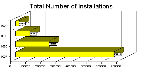
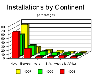
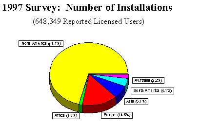
Number of Installations. The total number of licensed
users reported by the respondents to the 1997 survey is
648,349, which is a significant increase in the last two
years. The graph below shows the percentage of licenced
users by continent: North America 71.1 percent, Europe
14.6 percent, Asia 6.7 percent, South America 4.1 percent,
Australia 2.2 percent, and Africa 1.3 percent.
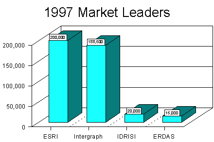
Market Leaders
The Environmental Systems Research Institute (ESRI), of
California, is the market leader in spatial data handling
software. ESRI reported 7,900 software installations in
1993, 130,000 in 1995, and 200,000 in 1997.
For the 1997 survey, Intergraph responded with a report of
188,500 software installations. The IDRISI Project at the
Clark University and ERDAS ranked as numbers three and
four, respectively. All of the major vendors are located in
the United States. Spatial data handling software
technologies are still relatively young, and many
companies are introducing new products at a fairly rapid
rate.
Cost of Software. The software systems represented in this survey vary widely in their functions and prices.
There are a few spatial data handling software packages that are in the public domain which means they are free of
charge. "Minimum cost" represents the basic software system, and "maximum cost" represents a complete or
fully capable software system. Cost is based on individual products where price was reported.
|
Minimum Cost |
Maximum
Cost |
| Minimum |
Free |
Free |
| First Quartile |
$695 |
$895 |
| Median |
$1500 |
$3000 |
| Third Quartile |
$4000 |
$10,000 |
| Maximum |
$40,000 |
$75,000 |
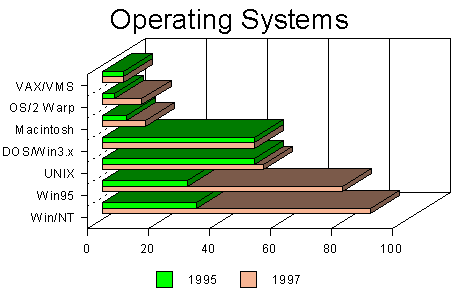
Operating Systems. The most common operating systems supported by the various software products in this survey
were Win/NT, Windows 95, and UNIX. This shows the migration from UNIX- and DOS/Win3.x-dominated
operating systems to the Windows 95 and Win/NT environment since 1995.
Data Exchange Formats.
In recent years, data have become more commonly available and are in diverse data
formats. The top three vector formats for data exchange are DXF, ARC/EXPORT, and DLG, and the top three
raster formats are TIFF, BMP, and JPEG.
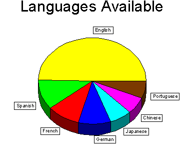
Languages Available. The dominant language is English with 110 products available. Only one software product
did not have an English version. The next most available language is Spanish with 25 products, followed by French
and German with 22 products, Japanese with 15 products, and Chinese and Portuguese with 14 products each.
Eleven products are offered in Russian and six in Arabic.
Summary of Findings
- There has been rapid growth in the installation of
spatial data handling software during the last few
years. However, the bulk of installations are
concentrated in North America (71.1 percent),
followed by Europe (14.6 percent). Developing
countries have not been able to participate in such
growth and, consequently, have limited capacities
to generate, maintain, and use spatial data
products.
- The global market is dominated by a handful of U.S. companies.
- The spatial data market is particularly well developed in North America, whereas the
European market seems to be still fragmented. Penetration in the markets of developing countries
is rather timid.
- Information technology tools are frequently being applied in daily life saving situations (such as 911
emergency calls in the United States) and such technology is growing into one of the largest and
most powerful businesses in the United States. However, developing counties are lagging, and
there is not much recognition of such tools and technologies for solving real life problems.
- In the developing world lack of infrastructure for the effective use of such information technology
tools is a significant limiting factor. Building up capacity in each country is the key for bridging
data gaps and providing access to information for decision making.
- Technology for spatial data conversion and creation is still complicated and expensive.
- Rapid advances in computer, remote sensing, GIS, global positioning systems (GPS), database
management, and the Internet offer an unprecedented opportunity to harness the potential
of such technologies to benefit the needs of developing countries. Vendors are rapidly
introducing new visualization and Internet-based tools in the market place. New powerful tools for
accessing, handling, analyzing, visualizing, and distributing integrated data sets are widespread in
the developed world. However, the technology gap between the developed and developing world
is increasing, and developing countries have to run faster to enter the "information age."
Acknowledgments
The authors offer their sincere appreciation to Gene Fosnight, Michelle Anthony, Norman Bliss, and Steve
Howard, Raytheon STX scientists, for their contributions. The support for this study was provided by the United
Nations Environment Programme (UNEP), the National Aeronautics and Space Administration (NASA) and the
United States Geological Survey (USGS).
Disclaimers
Mention of a commercial company or product in this report does not imply endorsement by UNEP, NASA, or
the USGS. Opinions expressed in this document are not necessarily those of UNEP, NASA, or the USGS.
For further information, please contact:
Ashbindu Singh
Regional Coordinator
UNEP Environmental Information & Assessment Program-North America
EROS Data Center
Sioux Falls, SD 57198, USA
Tel: 605-594-6107
Fax: 605-594-6119
E-mail: singh@edcmail.cr.usgs.gov
www: https://na.unep.net


