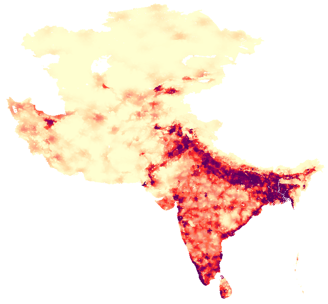
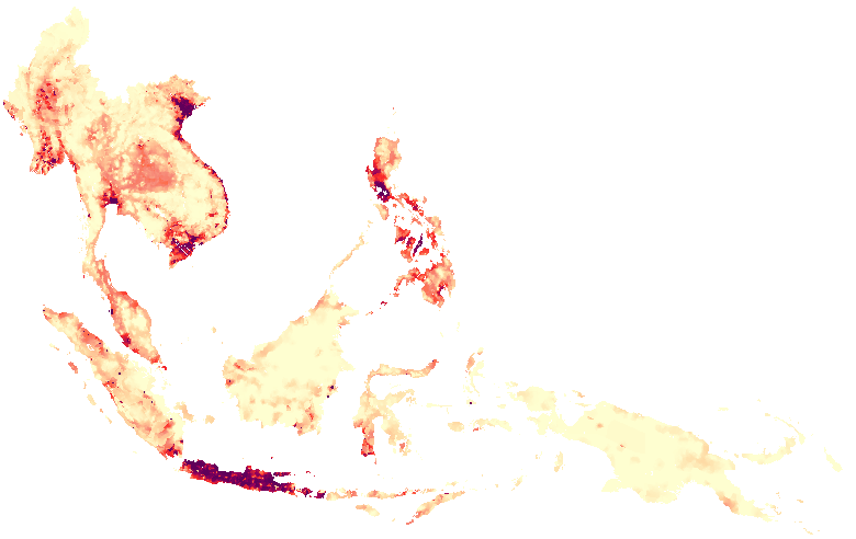
Country-specific documentation
Boundary data source:
World Data Bank II
Pop data sources:
1) Federal Statistical Office of Germany,
Laenderbericht: Afghanistan 1989, J.B. Metzler & C.E. Poeschel,
Wiesbaden, 1989.
2) Europa World Yearbook.
Population for 1984 from (1) and for 1982 from (2). The growth
rate 82-84 by province was adjusted by a constant (1.329) to yield a total pop 95 equal to
UN World Population Prospects national total
for 1995.
Boundary data source:
The original database was produced by the National Statistical
Office of Bangladesh in collaboration with the
UNSTAT/POPMAP Project
The original data were compiled in
POPMAP which so far does not support true georeferencing.
Source map scale and projection were unknown. The data were
first transformed into Transverse Mercator Projection (which
resulted in the lowest error among several possible projections
evaluated) and then projected into lat/long (ie, geographic)
coordinates. Rubbersheeting was then performed on the resulting
coverage to improve the match with the country and coastal
outline from the Digital Chart of the World (DCW). The likely
positional error is estimated (= guesstimated) to lie between 500m
and 1km (the RMS error in the transformation was below 1000m and
rubbersheeting should have improved the fit further). Thus, the
coverage is suitable for regional and continental scale applications
as well as for visualization of spatial pattern using census data.
It should not be used for high resolution applications at the
subnational level.
Pop data sources:
Pop figures computed using the average annual 81-91 growth
rate calculated from 1) and 2). In cases where
boundaries changed between 1981 and 1991, one of two approaches was taken:
a) if it was clear which district was split into which
new districts, the growth rate was assumed uniform for all
new districts.
b) if the disaggregation was not clear, the combined growth
rate for the entire second level administrative unit was
calculated and applied to all new third level units within
that second level unit.
Boundary data source:
Database obtained from UNEP/GRID Tsukuba, Japan,
based originally on World Data Bank II
Population data source:
District boundaries have changed in a number of instances since.
However, no data or detailed boundaries were available for the
new units.
POPEST95 estimated assuming constant growth rates across districts
and using the UN World Population Prospects
figure as the control total. Basis for estimation were the estimated
totals for '85 (based on the 82 census) published in 1).
Boundary data source:
No subnational boundaries available. National boundaries for
the two parts of Brunei were taken from the
Digital Chart of the World.
Pop data source:
Pop Data by district for 1981 only.
However, no subnational boundaries available. Only the
aggregate total for the 3 districts in the Western part:
- Muara 114231
- Seria/Belait 50768
- Tutong 21615
and the remaining total for the disjoint Eastern part
- Temburong 6218 (Eastern part)
were used. Total pop for 1995 from UN World Population Prospects.
These were split in proportion to the 1981 shares for the two regions.
Boundary data source
Boundaries were obtained from the Mekong River Commission Project
in Vientiane, Laos (Thomas Hoesli). Approximate scale 1:250,000.
The coverage was converted from UTM (Zone 48) into Latlong. The district names were taken from
a map produced by the UNITAC Cartographic Unit which had been
digitized by the Cambodia National Institute of Statistics for a
POPMAP application.
Pop data source:
Population data for 1994 are from the Cambodia National
Institute of Statistics and have been obtained in
digital form from the UNSTAT/POPMAP Project.
POPEST95 estimated by using the national-level average
growth rate for 1990-95 available from the UN World Population Prospects.
For the following three districts no population figures were available
Figures for these were estimated assuming the same density as the average
for the neighboring districts (this is a highly unreliable estimate!):
- Mongkol Borey
- Kiri Sakor
- Mondul Sema
For three provinces, no second level pop figures were available
for any district:
- Stoen Treng
- Mondol Kiri
- Takeo
For these provinces, the 1981 province pop totals from
Department of the Army, Cambodia: a Country Study. U.S. Government,
Secretary of the Army: Washington D.C., 1990 and were projected to 1995
using national-level average annual growth rates
for Cambodia from the UN World Population Prospects.
Growth rate: 3.039 % p.a.
The following districts contained in the POPMAP database
were aggregated to form Phnom Penh (DC) district:
- Chamkar Mon
- Prampi Makara
- Don Penh
- and Toul Kok.
For Don Penh, no pop figure was available. It was therefore
estimated assuming the same density as neighboring Toul Kok
district (resulting in 86169 people for Don Penh).
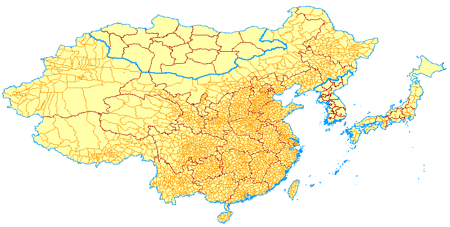
Boundary data source:
Coverage of counties for 1980 obtained from
National Geographic Society, Washington, D.C. (scale unknown) - see
July 1991 issue of NGS Magazine. Coverage was converted from
Albers projection into latlong coordinates.
Pop data sources:
- 1) Estimated 1987 population densities and areas from NGS coverage
- Poston, D. & Yaukey, D., The Population of Modern China ,
Plenum Press, New York: 1992.
Densities were converted into total population and uniformly
adjusted in each province to match the published 1990 province
totals from 2). The resulting county level estimates were
projected to 1995 using national growth rates. The resulting
estimates are likely to have limited accuracy.
Potential users of these data are encouraged to contact the
Consortium for
International Earth Science Information Network (CIESIN)
which will soon make a high quality China county coverage
for the 1990 available.
- Armenia
- Azerbaijan
- Georgia
- Kazakhstan
- Kyrgyzstan
- Russia
- Tajikistan
- Turkmenistan
- Uzbekistan
Boundary data source:
First Book, Oblast-level digital database for the former Soviet Union,
1:10mio., New World Demographics,
P.O. Box 866, Shady Side, MD 20764-0866.
Pop data source:
- 1) New World Demographics,
Baseline Demographics for the Republics of the Former Soviet Union,
Maryland, 1992.
Pop data available for 1992 only. POPEST95 derived by using national annual
growth rates for each former republic from UN World Population Prospects.
Boundary data source:
World Data Bank II
Pop data source:
POPEST95 derived using average annual growth rates for 1973 from 1) and 1992 from 2).
Boundary data source:
Digital Chart of the World.
Pop data source:
1991 Population for four parts of HKG (HKG Island, Kowloon and New Kowloon,
Marine, and New Territories) from 1).
Uniformly adjusted to match the 1995 total for HKG from the
UN World Population Prospects.
Boundary data source:
The original database was produced by the National Statistical
Office of Indonesia in collaboration with the
UNSTAT/POPMAP Project
The original data were compiled in
POPMAP which so far does not support true georeferencing.
Source map scale and projection were unknown. The data were
first transformed into a standard projection (chosen as the
one with the lowest error among several possible projections
evaluated) and then projected into lat/long (ie, geographic)
coordinates. Rubbersheeting was then performed on the resulting
coverage to improve the match with the country and coastal
outline from the Digital Chart of the World (DCW).
Based on the RMS error in the transformation,
the positional error introduced by these processing steps is
estimated (= guesstimated) to lie between 500m and 1km. Thus, the
coverage is suitable for regional and continental scale applications
as well as for visualization of spatial pattern using census data.
It should not be used for high resolution applications at the
subnational level.
Pop data source:
Population data from the National Statistical Office of Indonesia,
Census of 1990, were also provided by the
UNSTAT/POPMAP Project in
digital form.
No pop figures available for the following districts in
Kalimantan Tengah:
- Gunung Mas
- Katingan
- Barito Timur
- and Murung Raya.
Their population was estimated as their area times the average
population density of the neighboring districts (12.04 p/sqkm).
The accuracy of this estimate is likely to be limited.
POPEST95 derived by using '90 district totals and the district level
population growth rate for 1990 as recorded in the Indonesian Census
Office/UNSTAT-POPMAP
database.
Boundary data source:
Coverage of district boundaries for the 1981 census obtained
from Birkbeck College, London, Department of Geography. This
coverage was updated to correct labeling errors and missing
information and to incorporate changes between the 1981 and
1991 census. Various published sources were used for this purpose
including:
- India. Office of the Registrar General.
Census atlas : national volume : Census of India 1981, series 1, part XII
/ direction, B.K. Roy, general direction, V.S. Verma. New Delhi :
Controller of Publications, Civil Lines, c1988.
- Surya Kant. Administrative geography of India, Jaipur : Rawat
Publications, 1988.
Also used for reference was Indiamap, a comprehensive georeferenced
database distributed by Demosphere International, 4300 Fair Lakes
Court, Suite 300, Fairfax, VA 22033-4232, Fax: 703-802-0102.
Treatment of disputed areas:
Disputed areas were labeled separately using the following
country identifiers:
Areas disputed with Pakistan indicated by COUNTRY identifier of IN1,
those disputed with China have a COUNTRY code of IN2.
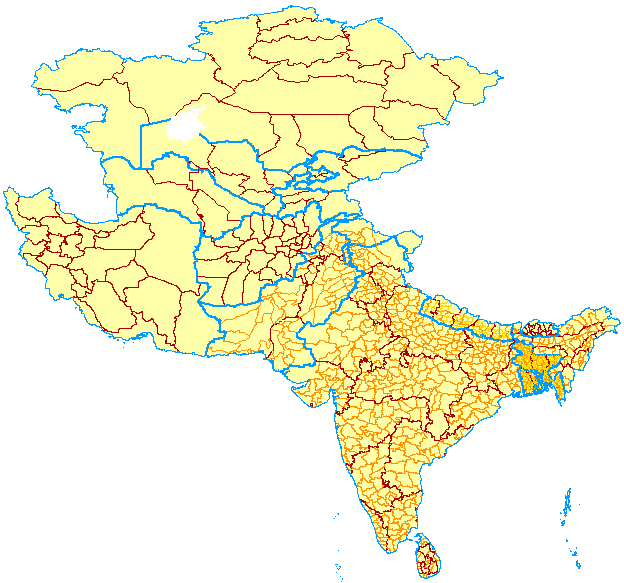
Pop data sources:
- 1) Controller of Publications,
Census of India 1981, series by state,
Delhi, 1982; Data for 1981 (as well as '61 and '71 data)
available in digital form via ftp from the
University of Maryland.
- 2) Director of Census Operations,
Census of India, 1991, Provisional population totals. series by state,
Delhi, 1992.
- IndiaMap (see above), was used as a secondary source.
POPEST95 estimated using district level growth rates for
the 1981-1991 period. In cases where districts were split
between the censuses, the same growth rate was assumed
the resulting new districts. The following 1991 districts
were created from a single 1981 district:
- Arunachal Pradesh:
- Tirap & Changlang
- West Kamang & Tawang
- Assam:
No district level estimates for 1981 available for Assam State - used
state level growth rates.
- Bihar:
- Dumka & Sahibganj & Godda & Deoghar <- Santhal Parg (Dumka)
- Gumla & Lohardaga & Ranchi
- Munger & Khagaria
- Saharsa & Madhepura
- Pashimi Singhhbum & Purbi Singhbhum
- Gaya & Jehanabad
- Jammu & Kashmir:
Using state level growth rate (2.54) for those districts for which '81
figures were available. For the areas disputed with / occupied by
Pakistan: Gilgit, figure from Europa Publications (statistics for
Pakistan, "Northern Areas") for 1981 projected using avg J&K growth rate.
Similarly for Chilas, Mirpur ("Azad Kashmir"). Accuracy of
the resulting estimates is VERY uncertain!
The Pakistani-held parts of this region are known as Azad ("Free")
Kashmir, with an area of 4,494 sq miles (11,639 sqkm) and a population of
1,980,000 in 1981, and Northern Areas (including Gilgit and Baltistan),
with and area of 28,000 sq miles (72,520 sq km) and a population of
562,000 in 1981.
Europa World Yearbook (information
for Pakistan).
- Haryana:
- Panipat & Karnal
- Kethal & Kurutshretra
- Kerala:
- Kollan & Pathanamithitta
- Kannur & Kasaragod
- Karnataka:
- Bangalore Urban & Rural
- Maharashtra:
- Aurangabad & Jalna
- Latur & Osmanabad
- Chandrapur and Garhchiroli
- Ratnagiri & Sindhudurg
- Manipur:
- Imphal & Bishnupur & Thoubal
- Rajasthan:
- Bharatpur & Daulpur
- Tamil Nadu:
- North Arcot & Tiruvannamalai
- Kamarajar & Pasumpon & Ramanathapuram
- Tirunelveli & Chidambaranar
- Madurai & Quaide Milleth
- Uttar Pradesh:
- Siddharthnagar & Basti
- Kandur Nagar & Kandur Dehat
- Firozabad & Mainpuri
- Maharajganj & Gorakhpur
- Maij & Azamgarh
- Saharanpur & Hardwar
- Sondbhadra & Mirzapur
- West Bengal:
- North & South 24 Panganas
- Goa:
- North and South Goa
Boundary data source:
World Data Bank II
Pop Data Source:
- 1) Statistical Centre of Iran, A Staticstical Reflection of The Islamic
Republic of Iran. Plan and Budget Organization: Islamic Republic of Iran:
1990.
- 2) US Census Bureau Int'l Database
POPEST95 based on the average annual province-level growth rate between
1976 (from 2) and 1986 (from 1).
Boundary data source:
World Data Bank II
Coverage includes Iraq/Saudi Arabia Neutral Zone, with a COUNTRY identifier
of 'IY' (as in WBDII), an ADMINID of 999000000, and a population of 0.
Pop Data Source:
- 1) Federal Statistical Office of Germany,
Laenderbericht: Irak 1988, J.B. Metzler & C.E. Poeschel,
Wiesbaden, 1988.
POPEST95 based on average annual province-level growth rates between
1977 (census totals) and 1985 (mid-year official estimates) from 1).
Boundary data source:
World Data Bank II
Coverage includes Israeli-occupied Golan Heights.
Pop Data Source:
- 1) Central Bureau of Statistics (1991), Statistical
Abstract of Israel 1991, no. 42, Jerusalem 1991.
POPEST95 based on average annual province-level growth rates between
1989 and 1990 from 1).
Boundary data source:
Database obtained from UNEP/GRID Tsukuba, Japan,
based originally on World Data Bank II
Pop Data Source:
- 1) Federal Statistical Office of Germany,
Laenderbericht: Japan 1990, J.B. Metzler & C.E. Poeschel Verlag, Wiesbaden, 1990.
- 2) Asahi Shimbun Publishing Company, Japan Almanac 1993, Tokyo, 1992.
POPEST95 based on average annual prefecture-level growth rates between
1988 from 1) and 1990 from 2).
Boundary data source:
World Data Bank II
Pop data source:
- Federal Statistical Office of Germany,Laenderbericht:
Jordanien 1992, J.B. Metzler & C.E. Poeschel Wiesbaden, 1992.
POPEST95 based on average annual growth rates between 1985 and 1990
from 1).
Boundary data source:
Database obtained from UNEP/GRID Tsukuba, Japan,
based originally on
World Data Bank II
Pop Data Source:
- 1) Eberstatdt, Nichola and Banister, Judith,
The Population of North Korea, Institute of East Asian Studies: Center for
Korean Studies, Berkeley, CA, 1992.
Only 1987 population available from 1).:
No other pop figures were available. Province level figures
were thus uniformly inflated using the 1995 total pop estimate
for PRK from UN World Population Prospects.
Boundary data source:
Database obtained from UNEP/GRID Tsukuba, Japan,
based originally on World Data Bank II
Pop Data Source:
- 1) The Korean Statistical Association, Korea
Statistical Yearbook Seoul, Korea, 1992.
POPEST95 based on average annual province-level growth rates between
1985 and 1990 from 1).
For 1985, no separate figures were available for the municpalities
of Taejon (included in Chungnam) and Kwangju (included in Chonnam).
For these, 1985 figures were estimated assuming the same proportion
of people in the municipal and the surrounding province
as in 1990. The 1995 estimate thus assumes a constant growth rate
in these cases.
Boundary data source:
The original database was produced by the National Statistical
Office of Laos in collaboration with the
UNSTAT/POPMAP Project
The original data were compiled in
POPMAP which so far does not support true georeferencing.
Source map scale and projection were unknown. The data were
first transformed into a standard projection (chosen as the
one with the lowest error among several possible projections
evaluated) and then projected into lat/long (ie, geographic)
coordinates. Rubbersheeting was then performed on the resulting
coverage to improve the match with the country and coastal
outline from the Digital Chart of the World (DCW).
The positional error resulting from this procedure is
estimated (= guesstimated) to lie between 500m
and 1km. Thus, the
coverage is suitable for regional and continental scale applications
as well as for visualization of spatial pattern using census data.
It should not be used for high resolution applications at the
subnational level.
Pop data source:
Population data from the National Statistical Office of Laos
Census of 1995, were also provided by the
UNSTAT/POPMAP Project in
digital form.
Boundary data source:
Birkbeck College, London
Pop data sources:
POPEST95 estimated using average annual growth rates between 1980 from 1)
and 1991 from 2).
Boundary data source:
Database obtained from UNEP/GRID Tsukuba, Japan,
based originally on
World Data Bank II
Pop data sources:
POPEST95 based on 1981 figures from 1) - these seem
to be rough estimates rounded to the nearest 10000 - and 1990
figures from 2).
Boundary data source:
Birkbeck College, London
Pop data source:
- 1) The Socialist Republic of the Union of Burma
1983 Population Census,
Ministry of Home and Religious Affairs, Immigration and Manpower
Department, October, 1987, (publications by state)
- 2) US Census Bureau Int'l Database
Population for 1983 census from 1) by townships (2nd level).
Publications for Arakan (Rakhine) and Chin State provided by
Dr. Griffith Feeney (East West Center, Hawaii).
POPEST95 estimated based on '83 township figures and state
level growth rates between 1973 (from 2) and 1983 (from 1).
The resulting estimates were very low when compared to the
total estimated pop in the
UN World Population Prospects
suggesting an increasing growth rate after 1983. The 73-83 growth rates
were therefore uniformly inflated by 1.3 to produce a
population total close to the UN estimated figure -> this
assumes that the growth rates increased uniformly throughout
the country!
Problems:
Arakan (Rakhine) State: No township polygon for Rathedaung
township (14th township). Pop for this township was therefore
added to Ponnagyun into which the town of Rathedaung falls.
Sagaing State: In the coverage, two townships were labeled Sagaing.
In comparing with a Myanmar map, one of them was identified to
be Sagaing township as it was located around the town with the
same name. The other one, further north, was determined to
be located around the town of Tantabin and was assigned that
label. However, the census pub for this state did not list
this township and all other townships were accounted for. But
the total population listed for the state minus the total for
the townships listed was not the same, and the residual -
32980 - was therefore assigned to Tantabin.
Shan State: Five townships - all located at the North-Eastern
border with China - were not listed in the census publication
most likely because of security reason - see note from the
census publication provided by Griffith Feeney:
"Shan state covers ... and consists of 52 townships. In these
townships there are 304 wards and 1632 village tracts. In carrying out the
enumeration, 304 wards were fully covered. Out of the total of 1632 village
tracts, 1142 were completely covered, 55 were partially covered and 435 were
uncovered for security reasons."
Therefore, the residual population between the state total and the
total for the 47 listed townships was distributed evenly to
the 5 townships which are of approximately even size.
Boundary data source:
Digital map produced by Royce Jones, Geographic Decisions Int'l,
2800 Woodlawn Drive #244, Honolulu, HI 96822.
Source map from Topographic Survey Branch, Survey of Nepal, scale: 1:500,000,
date unknown.
Pop data source:
- 1) Central Bureau of Statistics,
Statistical Yearbook of Nepal 1993, Kathmandu, Nepal, 1993.
- Data for Development regions, zones, districts.
POPEST95 estimated using average annual district-level growth rates
between 1981 and 1991. The resulting estimates were adjusted uniformly
to better match the national total given by the
UN World Population Prospects.
Boundary data source:
Boundaries do not represent administrative units!
Subnational administrative boundaries were unavailable. Instead the main town
corresponding to each of the Walayat (2nd subnational level) units was
identified, and Thiessen polygons were constructed to derive
regions.
The resulting coverage provides a crude approximation of political
subdivisions and gives a rough idea of population
distribution in the country only.
Pop data source:
- 1) Sultanate of Oman, Preliminary results of the General
Census of Population, Housing and Establishments, Muscat, 1993.
A few towns (6 and all in Al Wusta Governate/Region) could not
be identified. All of these had a very low population of about 10k
or less. Their population was distributed proportionately to
the remaining towns in the Governate/Region.
1993 figures were extrapolated using national growth rate from the
UN World Population Prospects.
(4.23% for 1990-95). Population includes Omani (74% of national total)
and non-Omani.
Boundary data source:
- Map Name: Pakistan: Administrative Regions (1983)
- Map Location: Unviversity of Texas, Map Room, General Library
- Call Number: G 7641 P7 1983 S9 PCL MAP
- Map Projection: Lambert Conical Orthomorphic
- Map Scale: 1:2,500,000
- Comments: Map includes international boarder with interior provinces.
- tic1: 24N, 62E
- tic2: 36N, 63E
- tic3: 36N, 78E
- tic4: 24N, 78E
- Digitized at NCGIA.
Int'l boundaries from DCW, except in disputed territory in the North,
the boundaries were replaced with the arcs from the Birkbeck College
India map. The disputed territories are included with the India coverage.
(see India documentation)
Pop data sources:
Data for 1981 from:
- 1) Federal Bureau of Statistics: Government of Pakistan,
Pakistan Statistical Yearbook 1989, Manager of Publications, Karachi 1989.
- 2) Population Census Organisation,
Handbooks of Population Census Data (by province except for NW Frontier Area),
Statistics Division, Govt of PAK, Karachi 1987.
POPEST95 estimation: Data were available for 1981 only. Total district
totals were thus based on separately estimated urban and rural population
shares (since the growth rates will be different depending on the degree
of urbanization).
Estimation of urban district population for 1995 using published urban percentage
figures from 2) and urban growth rates published in
UN World Urbanization Prospects;
-> rates for the three 5-year periods prior to 1995 (unavailable for
NW Frontier Area). Rural share estimated using average annual rates from
UN World Population Prospects.
ISO 3-letter code for Palestine unavailable - used PAL and the UNSTAT code
for Gaza (275).
Boundary data source:
Digital Chart of the World.
Pop data sources:
POPEST95 for Westbank estimated using 1993 figure from 1) and
growth rate of 2.9% p.a.
Boundary data source:
- Map Name: Philippines
- Map Location: Berkeley Library
- Call Number: 16300
- Map Projection: Lambert Conformal Conic
- Map Scale: 1:1,750,000
- Comments: Map includes most islands as well as regional
and provincial boundries.
- tic1: 21N, 116E
- tic2: 21N, 128E
- tic3: 4N, 127E
- tic4: 4N, 116E
- Digitized at NCGIA.
Pop data source:
- 1) National Statistical Coordination Board,
1990 Philippine Statistical Yearbook,
Republic of the Philippines, 1990.
POPEST95 derived using average annual growth rates
based on census population figures for 1980 and 1990
from 1).
Boundary data source:
Digitized at NCGIA from 1990 CIA Map at 1:6 mio scale.
Pop data source:
POPEST95 based on 1992 population estimates and national
level growth rates from UN World Population Prospects
Boundary data source:
Birkbeck College, London
Pop Data Source:
- 1) Registrar General's Department (1993), Statistical
Abstract of Sri Lanka 1993, Dept. of Census and Statistics,
Ministry of Planning and Implementation, p. 26 & 35; census
figures for 1981, estimated mid-year pop for 89 and 92.
A new district, Kilinochchi, was created in 1986. However, the
boundaries for this district were not available. Similarly,
the 1981 figures for this new district based on the census
were not published. From the location of Kilinochchi town,
and an examination of growth rates for the districts in its
vicinity, it was judged that the new district was created from
Jaffna district rather than from Mullaitivu.
The '89 and '92 pop for Kilinochchi (97,000 and 104,000 respectively)
were therefore added to Jaffna district total (raising its 81-92
growth rate to 1.49 from 0.47).
POPEST95 estimated using calculated district level growth rates
from 1989 to 1992 from 1).
Sri Lanka did not have a census since 1981. All censuses have been cancelled
until further notice.
Information provided by Patrick Gerland, UNSTAT/NY.
Boundary data source:
World Data Bank II
Pop data source:
- 1) Federal Statistical Office of Germany,
Laenderbericht: Syrien 1990, J.B. Metzler & C.E. Poeschel,
Wiesbaden, 1990.
POPEST95 based on average annual growth rates between 1980 and 1985
from 1).
Boundary data source:
Birkbeck College, London
Pop data sources:
- 1) National Statistical Office,
1990 Population and Housing Census, Thailand, Pho. So. 2533,
Office of the Prime Minister,Bankok, 1990
- 2) US Census Bureau Int'l Database
POPEST95 based on average annual growth rates calculated using
1990 census figures from 1) and 1980 figures from 2). To account
for the very large resulting estimate (possibly due to
declining fertility rates = declining growth rates), a deflator
of 0.7 was used to adjust the growth rates downward. The deflator
was chosen so that the total pop for Thailand matched the total
pop estimate for the country published in
UN World Population Prospects.
Nakhon Phanom province in the Northeastern Region (across the border
from Laos (Savannakhet) was split between the 1980 and 1990 census
to create the new province Mukdahan. Since the exact new boundary
was unavailable, Mukdahan's 1990 pop figures were added to Nakhon
Phanom province (ADMINID: 764040400). Mukdahan was assigned a
unique identifier.
Boundary data source:
World Data Bank II
Pop data source:
- 1) State Institute of Statistics, Statistical Yearbook of Turkey, Prime
Ministry Republic of Turkey: 1991.
POPEST95 based on average annual growth rates derived using census
figures for 1985 and 1990 from 1)
Boundary data source:
World Data Bank II
Pop data source:
- 1) Federal Statistical Office of Germany,
Laenderbericht: Vereinigte Arabische Emirate 1990, J.B. Metzler & C.E. Poeschel,
Wiesbaden, 1990.
POPEST95 based on average annual growth rates between 1980 and 1985
from 1).
Boundary data source:
The original database was produced by the National Statistical
Office of Vietnam in collaboration with the
UNSTAT/POPMAP Project
The original data were compiled in
POPMAP which so far does not support true georeferencing.
Source map scale and projection were unknown. The data were
first transformed into a standard projection (chosen as the
one with the lowest error among several possible projections
evaluated) and then projected into lat/long (ie, geographic)
coordinates. Rubbersheeting was then performed on the resulting
coverage to improve the match with the country and coastal
outline from the Digital Chart of the World (DCW).
Based on the RMS error in the transformation, the
positional error is estimated (= guesstimated) to lie between 500m
and 1km. Thus, the
coverage is suitable for regional and continental scale applications
as well as for visualization of spatial pattern using census data.
It should not be used for high resolution applications at the
subnational level.
Pop data source:
Official population estimates for 1992 based on the National Statistical
Office of Vietnam, Census of 1989, were also provided by the
UNSTAT/POPMAP Project in
digital form. These were uniformly forecast to 1995 using national
level growth rates.
Boundary data source:
World Data Bank II
Pop data sources:
Governate figures for 1986 for former North Yemen (Aden) from
Europa Publications (1995), Middle East and North Africa 1995,
41st ed., London. Figure for 1981 for former South Yemen (Sana) - country-level data
available only from Cambridge Gazetteer.
- Bahrain
- Kuwait
- Lebanon
- Macau
- Maldives
- Papua New Guinea
- Qatar
- Singapore
Boundary data source:
Digital Chart of the World.
Pop data source:
Birkbeck College, Department of Geography, London.
Based on World Databank II (see below). District names
were added at NCGIA.
Defense Mapping Agency, Digital Chart of the World, digital
data, 1:1 mio sclae, 1994,
Arc/Info version produced by
Environmental Systems Research Institute.
Europa Publications Limited, The Europa World Yearbook:
a) Middle East and North Africa 1994-40th ed. & 1995-41st ed.,
b) The Far East and Australasia 1994-25th ed. & 1995-26th ed., London.
Munro, David. Cambridge World Gazetteer: A Geographical Dictionary.
Cambridge University Press, New York: 1990
United Nations Population Division, World Population Prospects -
The 1994 Revision
Department for Economic and Social Information and Policy Analysis, New York, 1994.
The medium variant estimate was used in all cases.
United Nations Population Division, World Urbanization Prospects -
The 1992 Revision.
Department for Economic and Social Information and Policy Analysis, New York, 1992.
Software Development Project (POPMAP), UN Statistical Division,
DESIPA, New York (contact:
Vu Duy Man, vu @un.org, or Patrick Gerland, gerland @un.org).
U.S. Bureau of the Census, International Database,
digital data, Center for International Research, Washington DC, no date.
U.S. Government, World Data Bank II - 1:3 million, 1988,
Arc/Info version produced by
Environmental Systems Research Instititue.


