|
Having trouble reading this email? Download the PDF.

Thematic Focus: Disasters and Conflicts, Harmful Substances and Hazardous Waste, and Ecosystem Management
The Gulf of Mexico Oil Spill:the Worlds Largest Accidental Offshore Oil
Why is this issue important?
The Gulf of Mexico, which covers about 1 554 000 km2, is the world's ninth-largest body of water and has been called the "Mediterranean of the Americas."
More than 60 per cent of the water drained from 33 major river systems and 207 estuaries in the United States enters the Gulf, which receives additional freshwater
inputs from the Yucatan Peninsula and Cuba. Some of the world's most productive fisheries operate in the Gulf of Mexico: in 2008, the commercial fish and shellfish
harvest was estimated at approximately 590 million kilograms and was valued at US$661 million. The Gulf is extremely important to regional economies. In 2006, it
produced 470 million barrels of oil and about 82 million m3 of natural gas. Its offshore operations produce a quarter of the U.S.'s domestic natural gas and
one-eighth of its oil and provide jobs for over 55 000 U.S. workers. In addition, the region supports a US$20 billion tourist industry. The Gulf's wetlands, which comprise
about half of the country's total wetland area, and its other marine and estuary ecosystems are also very important habitats for both wildlife and commercial species (US EPA 2010a).
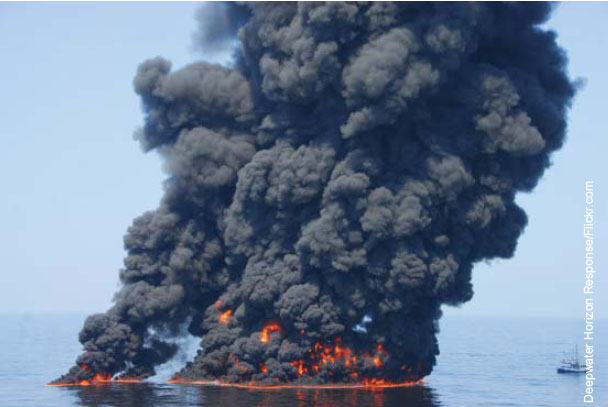

Figure 1: Approximate oil location on 22 April 2010. Approximation based on overflight information. The oil slick was confined to the immediate area surrounding the location of the exploded rig.
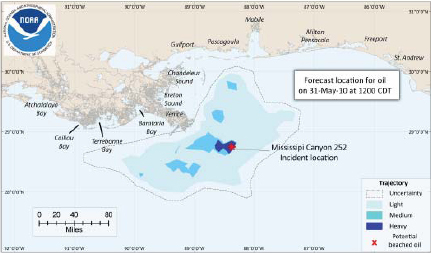
Figure 2: Nearshore Surface Oil Forecast Deepwater Horizon MC252 based on the National Weather Service (NWS) spot forecast from 31 May PM.
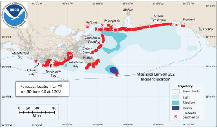
Figure 3: Nearshore Surface Oil Forecast Deepwater Horizon MC252 based on the National Weather Service (NWS) spot forecast from 30 June PM.
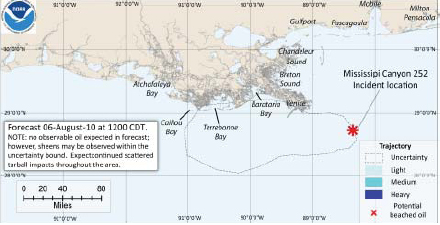
Figure 4: Nearshore Surface Oil Forecast Deepwater Horizon MC252 based on the National Weather Service (NWS) spot forecast from 5 August PM. This map shows no observed oil on the water surface.
On 20 April 2010, a huge fire engulfed a Deepwater Horizon petroleum-drilling rig that had exploded in the Gulf of Mexico, killing 11 platform workers and injuring 7 others. After burning for hours,
the rig sank on 22 April, resulting in the spread of a large oil slick from the location of the former rig. Over a period of 100 days, attempts were made to stop the oils gushing and to control its spread.
In early June, the U.S. government imposed fishing restrictions covering 37 per cent of U.S. federal waters in the Gulf. Finally, on 15 July, British Petroleum (BP) succeeded in fitting a tight sealing containment
cap, which stemmed the leak (TRF 2010). U.S. government data show that 4.9 million barrels of oil leaked before the well was capped.
What are the findings and implications?
The maps on the previous page (all modified from the NOAA Deepwater Horizon 24Hr Offshore Maps) show a time-series of the oil's spread over the Gulf waters between 22 April and 6 August.
They illustrate the oil's trajectory from the incident's location towards land, aided by wind and sea currents. The maps were produced by using several models of water currents (NOAA Gulf of Mexico,
West Florida Shelf/USF, TGLO/TAMU, NAVO/NRL) and high-frequency radar measurements.
The media has called the event the world's largest accidental offshore oil spill (Chediak 2010, New York Times 2010). In mid-August, about 1 086 km of Gulf Coast shoreline had been affected
and approximately 136 000 km2 of Gulf of Mexico federal waters were still closed to fishing. An interagency report estimated that burning, skimming and direct recovery removed 25
per cent of the oil, another 25 per cent evaporated or dissolved, 24 per cent was dispersed and 26 per cent is either on or just below the surface, has washed ashore or is buried in sand
and sediments (Deepwater Horizon 2010).
The oil spill had significant impacts on wetland and marine species that became covered in oil when they encountered the oil slick, including gannets, brown pelicans and other shore birds.
By 1 July, response teams had collected 594 stranded sea turtles, of which 441 had already died (CBD 2010).
According to the United States Environmental Protection Agency (US EPAa), there were low levels of odour-causing pollutants associated with oil in sampled air and surface water samples did not
reveal elevated levels of chemicals usually found in oil (water samples collected between 9 and 10 June and 6 and 11 August 2010 along the Gulf Coast). However, sediment samples collected between
8 and 10 June and 2 and 9 August 2010 found nickel that exceeded chronic aquatic life benchmarks (US EPA 2010b). Nevertheless, the Gulf's vegetation and wildlife is already recovering (NOLA 2010).
The implications of the oil spill include future decisions about large-scale oil drilling versus investments in energy efficiency and renewable energy. The global community has learned that future
oil and gas developments must be subjected to stringent risk and environmental impact assessments.
References
CBD (2010). Gulf Disaster: End Offshore Drilling Now. Center for Biological Diversity. http://www.biologicaldiversity.org/ (Accessed on August 22, 2010)
Chediak, M. (2010). BP's Gulf oil leak ranks as world's worst caused by an accident. Bloomberg Business and Financial News, 3 August. www.bloomberg.com/news (Accessed on 23 August 2010)
Deepwater Horizon (2010). Deepwater Horizon Response web page. http://www.deepwaterhorizonresponse.com (Accessed on 23 August 2010)
ERMA (2010). Environmental Response Management Application. National Oceanographic and Atmospheric Administration. http://gomex.erma.noaa.gov (Accessed on 24 June 2010)
New York Times (2010). Gulf of Mexico Oil Spill (2010), Times Topics, 20 August. http://topics.nytimes.com/ (Accessed on 23 August 2010)
NOAA (2010). Deepwater Horizon Incident, Gulf of Mexico. National Oceanographic and Atmospheric Administration. Available online at http://response.restoration.noaa.gov/ (Accessed on 24 June 2010)
NOLA (2010). New Orleans Louisiana. Marshes fouled by Gulf of Mexico oil spill show signs of regrowth.(Accessed on 19 August 2010)
TRF (2010). Thomson Reuters Foundation, AlertNet. Timeline - Gulf of Mexico Oil Spill. http://www.alertnet.org/ (Accessed on 19 August 2010)
US EPA (2010a). EPA Response to BP Spill in the Gulf of Mexico. US Environmental Protection agency. http://www.epa.gov/bpspill/ (Accessed on 19 August 2010)
US EPA (2010b). Gulf of Mexico Program: General Facts about the Gulf of Mexico. Environmental Protection Agency. Available at http://www.epa.gov/gmpo/about/facts.html (Accessed on 23 August 2010)
Information is regularly scanned, screened, filtered, carefully edited, and published for
educational purposes. UNEP does not accept any liability or responsibility for the accuracy, completeness, or any other quality of information and
data published or linked to the site. Please read our privacy policy and
disclaimer for further information.
|