|
Having trouble reading this email? Download the PDF.

Thematic Focus: Ecosystem Management, Disaster and Conflicts, and Climate Change
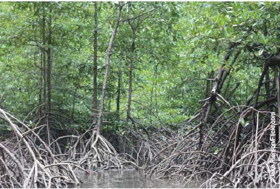
Global Mangrove Extent Much Smaller than Previously Estimated
Why is this issue important?
As confirmed by the impacts of the December 2004
Asian tsunami and Hurricane Katrina in 2005, intact
mangroves help stabilize shorelines and thus protect
lives and property from such natural disasters. They
also provide other ecosystem services, such as
breeding and nursing grounds for marine species and
sources of food, medicine, fuel, and building materials
for local communities. In addition, living mangroves
store carbon, keeping it out of the atmosphere. It is
possible that mangroves and the soils they grow in
could sequester about 22.8 million metric tonnes of
carbon each year. Mangrove forests occur between
the sea and land and are thought to cover about a
quarter of the worlds tropical and subtropical intertidal
zones, mostly between 5° N and 5° S latitude.
Research reveals that the forests have been declining
at an alarming rate, howeverperhaps even faster
than inland tropical forestsand much of what is left
is degraded. From 1980 to 2000, mangroves around
the world declined by an estimated 35 per cent.
Remaining mangrove forests are under immense
pressure from clear cutting, especially for farming and
aquaculture; encroachment; hydrological alterations;
chemical spills; storms; and climate change. Until
recently, however, little was known about their current
distribution, rate and causes of deforestation, and
potential rehabilitation sites (Giri and others 2010).
What are the findings and implications?
In 2010, the most comprehensive and globally
consistent worldwide mangrove database to date was
created using thousands of satellite images with the
highest resolution (30 m) possible (Giri and others
2010). Analysis found that the total area of mangroves
in the year 2000 was 137 760 km2 in 118 countries and territories in the world's tropical and subtropical
regions. The largest mangrove extent is found in
Asia (42 per cent) followed by Africa (20 per cent),
North and Central America (15 per cent), Oceania
(12 per cent) and South America (11 per cent).
Approximately 75 per cent of mangroves are
concentrated in just 15 countries. Only 6.9 per cent fall
within existing protected areas networks (under IUCNs
I-IV categories). Analysis of the satellite imagery found
that mangroves have declined significantly more
than previously estimatedthey cover an area that is
12.3 per cent smaller than the most recent estimate
by the Food and Agriculture Organization (FAO) of the
United Nations.
A previous study of satellite images of coastal
areas affected by the 2004 tsunami (Giri and others
2007a) shows that from 1975 to 2005, the region
lost 12 per cent of its mangrove forests. Agricultural
expansion was the major cause, accounting for
81 per cent of losses. Although aquaculture was
responsible for only 12 per cent, the industry is
growing rapidly. In Thailand, agricultural expansion
accounts for half the mangrove losses, but aquaculture
is now responsible for 41 per cent. As aquaculture
develops, there is a clear need to consider the
mangrove forests value in protecting coastlines
and other ecosystem services, which in some areas
may be higher in the long term than the economic
value of shrimp farming (Ranganathan and others
2008). Giri and others (2007b) shows that mangrove
conservation and development need not be mutually
exclusive. Population density around the Sundarbans
mangrove forests in Bangladesh and West Bengal
is the highest in the world. The area covered by
mangroves, however, has changed little over the past
25 years, due to the presence of reserves and other
conservation areas, although human activities are
degrading the forests condition.
The information generated by these studies can
be used to better understand the role of mangrove
forests in saving lives and property from natural
disasters such as tsunamis; identify possible areas
for conservation, restoration and rehabilitation; and
improve estimates of the amount of carbon stored
in mangrove vegetation and the associated marine
environment (blue carbon).
References:
Giri, C., Zhu, Z., Tieszen, L., Singh, A., Gillette, S., Kelmelis, J. (2007a) Mangrove forest distributions and dynamics (1975-2005) of the tsunami-affected region of Asia Journal of Biogeography 35 (3), 519-28.
Giri, C., Pengra, B., Zhu, Z., Singh, A., Tieszen, L. (2007b). Monitoring mangrove forest dynamics of the Sundarbans in Bangladesh and India using multi-temporal satellite data from 1973 to 2000. Estuarine, Coastal and Shelf Science 73, (1-2), 91-100.
Giri, C., Ochieng, E., Tieszen, L., Zhu, Z., Singh, A., Loveland, T., Masek, J., Duke, N. (2010). Status and distribution of mangrove forests of the world using earth observation satellite data. Global Ecology and Biogeography, Published online 17 August.
|