|
Having trouble reading this email?
Download the PDF.

Thematic focus: Climate change, Ecosystem management, Environmental governance
Balancing economic development and protecting the cradle of mankind - Lake Turkana basin
Cooperation on the Omo-Turkana transboundary water issues needed
A number of transboundary water agreements exist in Africa. However, many of these agreements are limited to larger basins such as the Nile, Niger, Senegal or Volta.
There are very few international river basin agreements or cooperative arrangements in the small
transboundary basins where development activities such as dam building and/or irrigation development are currently taking place.
Such changes affect water redistribution and could pose, on one hand, a potential threat for conflict, on the other hand, could
provide opportunities for cooperation.
Why is this issue important?
The United Nations (UN) General Assembly has declared 2013 as the United Nations International Year of Water Cooperation.
The objective of this International Year is to raise awareness, both on the potential for increased cooperation, and on the
challenges facing water management in light of the increase in demand for water access, allocation and services. The Year
will highlight the history of successful water cooperation initiatives, as well as identify key issues on water education,
water diplomacy, transboundary water management, financing cooperation, national/international legal frameworks, and the
linkages with the Millennium Development Goals (MDG).
The Intergovernmental Panel on Climate Change (IPCC) Technical Paper on Climate Change and Water stressed the fact that increased
demand and reduced availability of fresh water under global climate change will significantly affect global food security in
the 21st century (Bates et al., 2008). Furthermore, Wolf et al. (1999) emphasised that the challenges to integrated watershed
management are compounded when water resources cross international boundaries. Both regional and cross-sectorial cooperation
are important for addressing the water-food-energy nexus in transboundary basins.
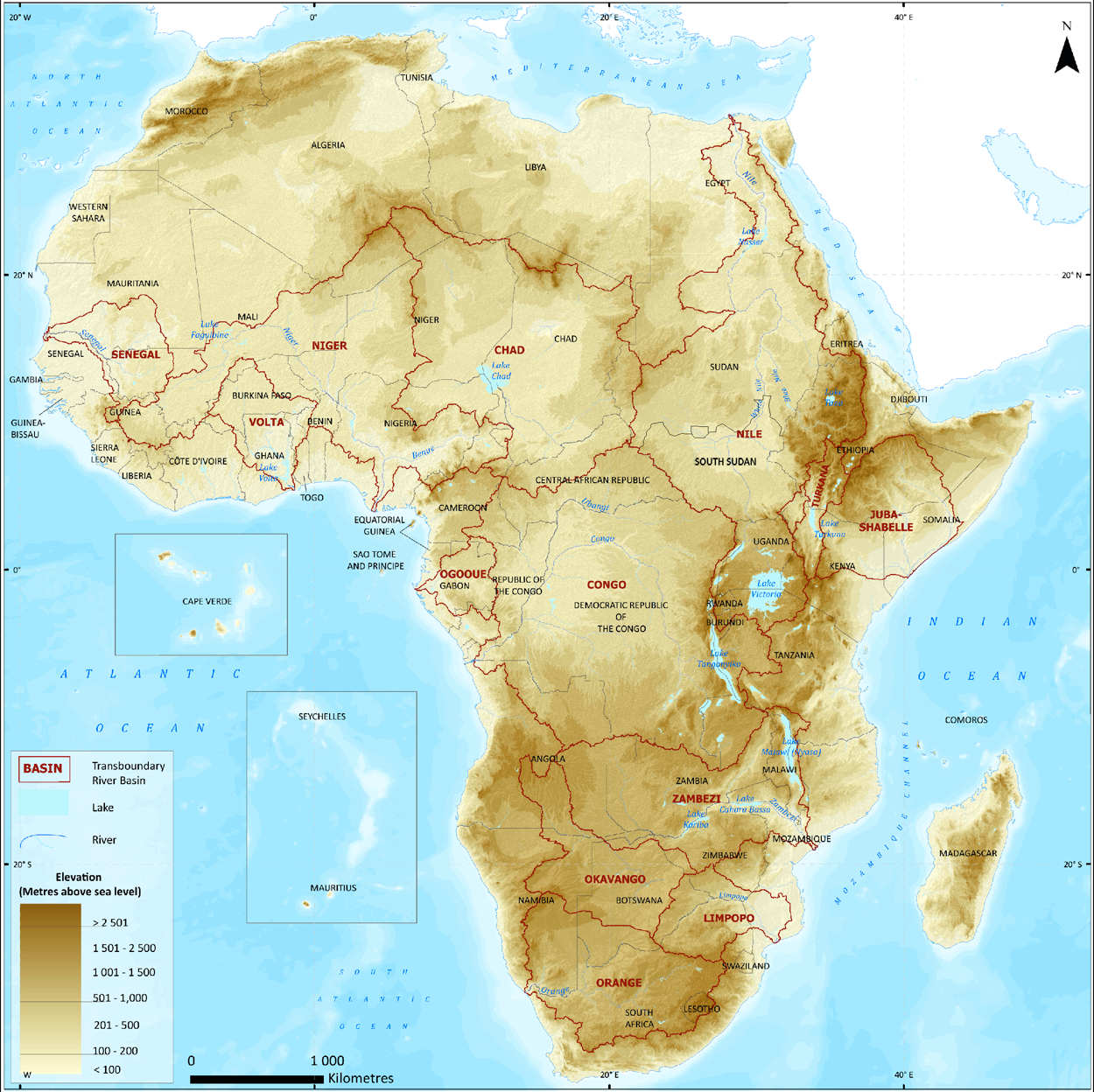
Transboundary basins and water cooperation in Africa
Compared to the other continents in the world, Africa has the highest percentage of land area (62%) within transboundary basins.
It is interesting to note that with the obvious exception of island states, all sub-Saharan African countries share at least one
international river basin. In fact, the region has more transboundary river basins than countries. Depending on the source,
there are about 61 to 80 transboundary river and lake basins in Africa. Figure 1 shows major transboundary river basins (small international basins are not shown). This accounts for around one fourth of the
total transboundary basins and about one-third of the world's major international river basins (basins larger than 100,000 km2).
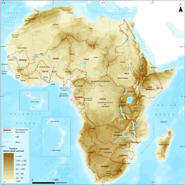
Figure 1: Major transboundary basins in Africa. Source: UNEP, 2010.
Full Size Image
A number of transboundary water agreements exist in Africa. For example, according to Lautze et al. (2005), there were up
to 15 agreements in the Nile River basin between 1925 and 2003, 6 in the Senegal River basin between 1963 and 1988, 10 in the Niger
River basin and 3 in the Volta River Basin over the last several of decades. Although several other agreements or cooperation
arrangements exist which serve different objectives and purposes, such agreements and cooperative use of water has been limited
to the large international river basins. Presence of very few international river basin agreements or cooperative arrangements
in the smaller international transboundary basins poses a potential threat to water conflict as smaller international basins
are currently experiencing basin developmental activities such as dam building and irrigation development.
Hydropower projects in Africa
Hydropower contributed up to 16.5% of the global electricity production, or up to 3/4 of the total global estimated renewable
energy share, by the end of 2012 (REN21, 2013). Based on multiple sources, the Renewable 2013 Global status report summarised that globally,
hydropower generated an estimated 3,700 TWh of electricity during 2012, including approximately 864 TWh in China,
followed by Brazil (441 TWh), Canada (376 TWh), the United States (277 TWh), the Russian Federation (155 TWh), Norway (143 TWh), and India (>116 TWh).
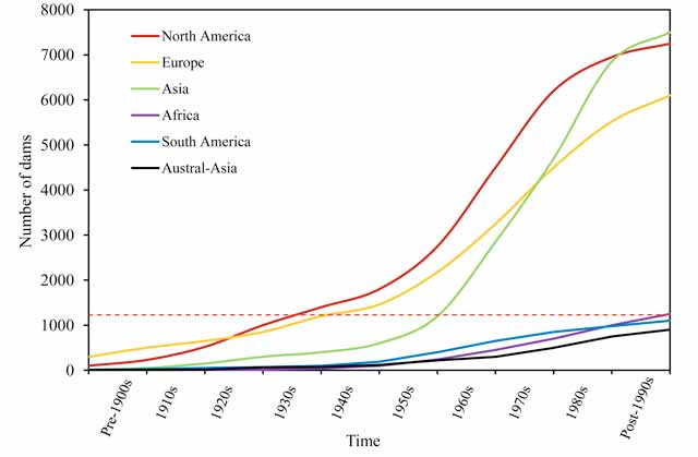
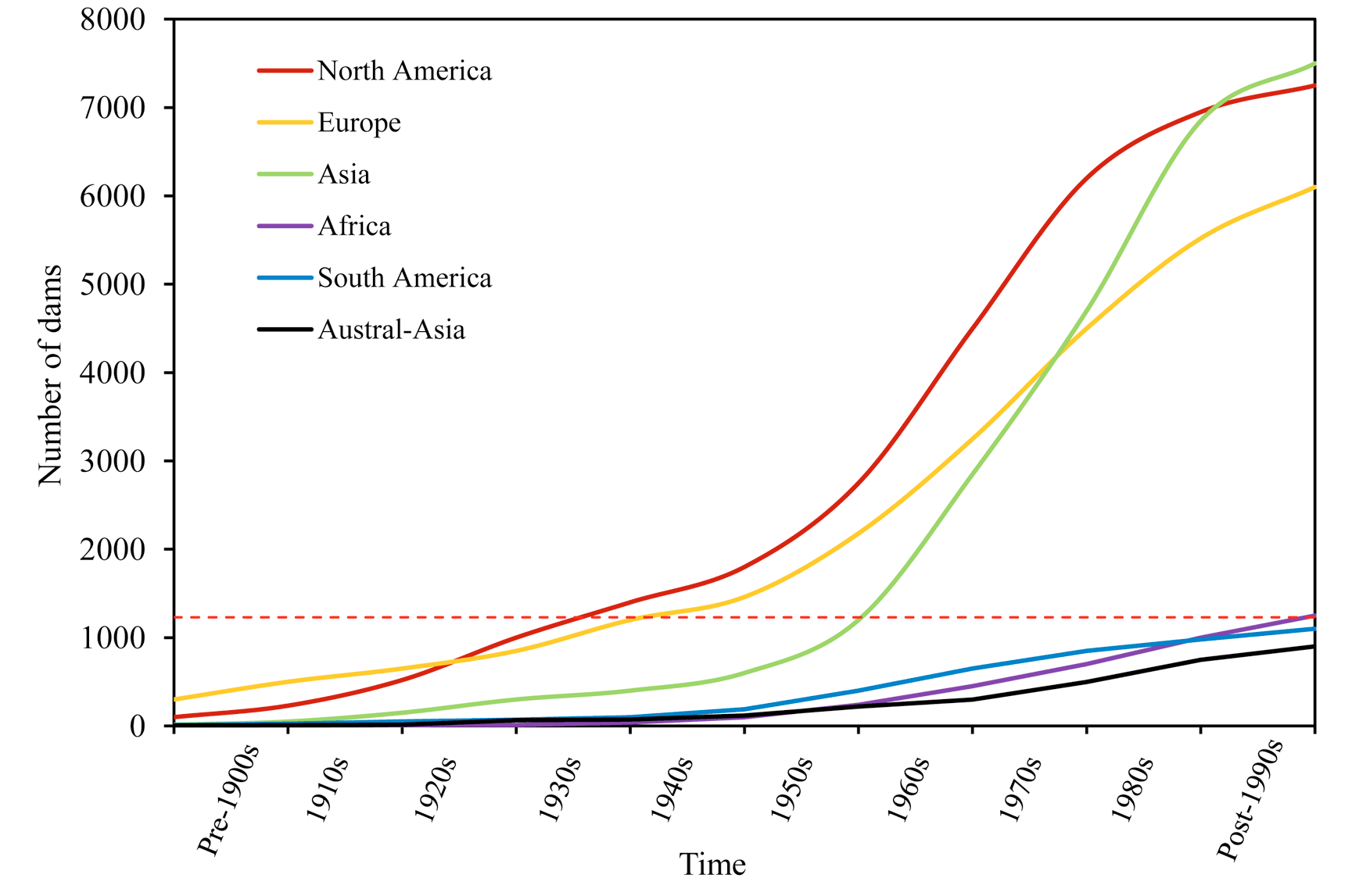
Figure 2: Global distribution of dams between years 1900 2000. Source: modified from WCD, 2000.
Note: Information excludes the time-trend of dams in China. The red dashed line compares the number of dams in Africa by the end of 20th century with other continents.
Full Size Image
It is estimated that globally, approximately two-thirds of the economically feasible potential locations for dam construction remain to be
developed. Untapped hydro resources are still abundant in Latin America, Africa, India and China. Africa has plentiful water resources
for hydroelectricity and can boost energy security and economic development by increasing hydropower development with appropriate social
and environmental safeguards. Currently electricity production in Africa is the lowest in the world. Although Africa has the second largest
population after Asia, it has the lowest energy consumption per capita of any continent. Many African nations have per capita electricity
consumption of less than 80 kWh/yr compared to 26,280 kWh/yr in Norway, 17,655 kWh/yr in Canada and 13,800 kWh/yr in the United States (Bartle, 2002).
Technically, feasible hydropower, estimated at nearly 15,000 TWh/yr, still exists in the world today. However, it is mostly in countries where
increased power supplies from clean and renewable sources are most urgently needed to progress social and economic development (Kaygusuz, 2004).
The technically feasible hydropower potential of Africa is around 1,750 TWh which is about 12% of the global capacity. However, only about 4% of
this technically feasible potential had been exploited by 2002 (Bartle, 2002).
Thus, Africa is referred to as an "under-dammed" continent (The Economist, 2010). Only 3% of its renewable water is used, against 52% in
Asia and 21% in Latin America. Figure 2 shows the growth of dams between years 1900 2000 globally. As shown by the red dashed line in Figure 2,
the number of dams in Africa (around 1,200) by the end of 20th century is equal to the number of dams that were built in North America or Europe
by mid-1940s or in Asia by the end of 1950s. A green revolution in Africa would not be possible without increasing water storage and availability.
Although several new dam projects are currently underway in African nations, many of them are happening in the international river basins which
do not have transboundary agreements in place. Here we are highlighting the example of Gibe dams in Ethiopia and their potential impact on Lake
Turkana water levels. Also, the need for a transboundary water cooperation and management arrangement or mechanism in the Lake Turkana basin is stressed.
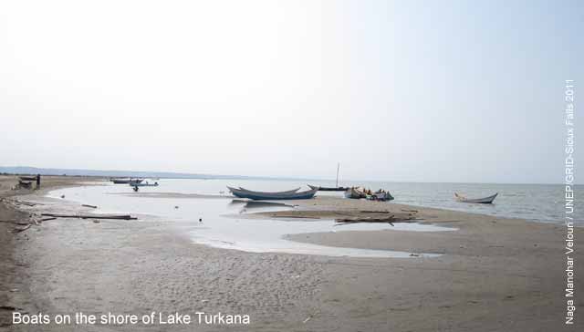
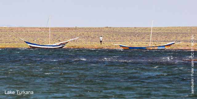
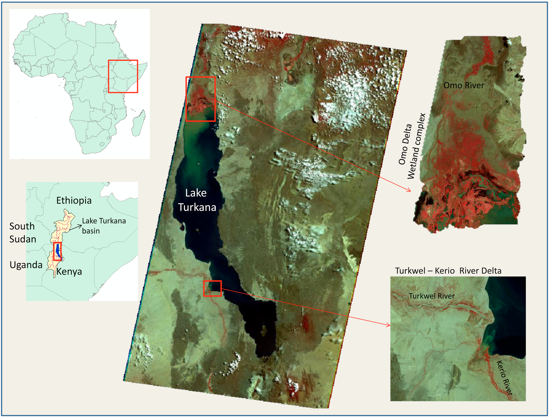
Lake Turkana basin the cradle of mankind
Lake Turkana is the largest saline lake among the most northerly of the Rift Valley lakes; its watershed extends into Ethiopia, Kenya, South Sudan and
Uganda (Figure 3). The lake is 250 km long, 1530 km wide, has an area of nearly 7,000 km2 and is the fourth largest lake in Africa by volume. It has a
maximum depth of 125 m and an average depth of 35 m. It is believed that this is where human life is expected to have begun, therefore the Lake Turkana
area is considered the cradle of mankind (Amin, 1983).
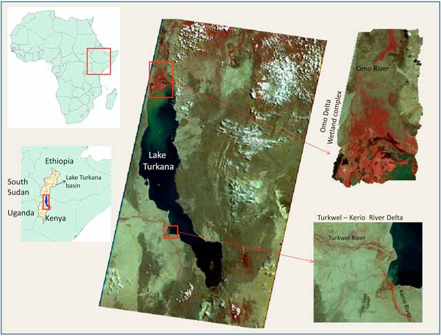
Figure 3: Location of Lake Turkana - the cradle of mankind - located in East Africa; insets show Lake Turkana and Omo, Turkwel and Kerio River Deltas.
Full Size Image
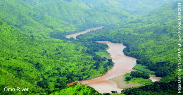
More than 80 per cent of inflows to the lake come from the Omo River in Ethiopia (Cerling 1986; Ricketts and Johnson, 1996). The Omo River is perennial
and flows nearly 1,000 km from north to south before ending in Lake Turkana. Most of the remaining inflows come from two southern tributaries, the Turkwel
and Kerio Rivers. Lake Turkana is considered an endorheic or closed lake because there is no surface outlet and insignificant seepage. The outflow is
almost wholly dominated by evaporation. The annual loss through evaporation is estimated to be around 2.4 m (Velpuri and Senay, 2012). Rainfall over the
lake can be as low as 200 mm/year (UNEP, 2013).
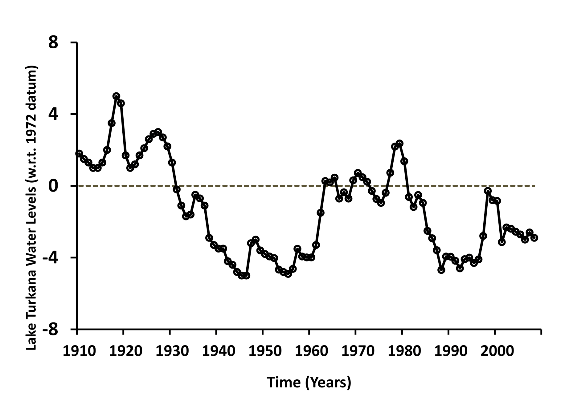
Lake Turkana's water levels usually show seasonal fluctuations of 34 m. Generally, the annual amplitude of lake-level fluctuation is 11.5 m,
but it also undergoes considerable long-term variations that exceed those of any other lakes of natural origin (Butzer, 1971).
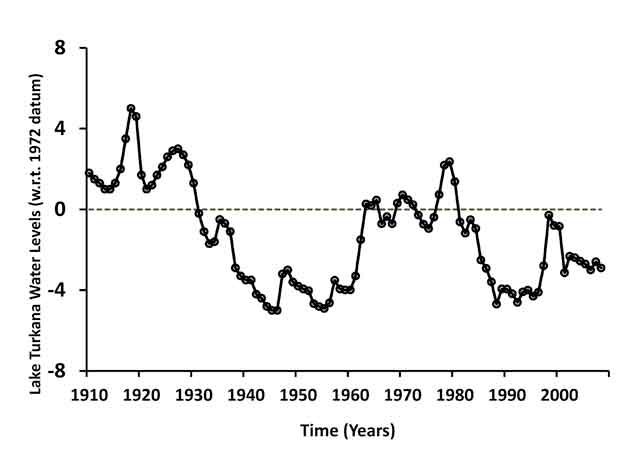
Figure 4: Lake Turkana water levels in the 20th century. Source: Data from Kenya Marine and
Fisheries Research Institute (KMFRI).
Full Size Image
Paleolimnological studies indicate that during the Holocene period, the lake level was about 6080 m higher than the present-day level and that
it was connected to the Nile River (Yuretich, 1979). The current lake has no outlet and the mean lake level is 360 m above sea level. In 1988,
Kallqvist et al. (1998) synthesised Lake Turkana's water levels for the previous 100 years and concluded that around 1895, the lake was about
20 m higher than in 1988. The lake declined gradually during the first half of the 20th century, reaching its lowest level in the 1950s,
after which there was a rapid increase in the 1960s through the 1970s, with the peak level attained during late 1970s and early 1980s (Figure 4).
The Gibe hydroelectric power projects in Omo River basin, Ethiopia
With abundant rainfall and suitable physical features, Ethiopia has several potential sites for hydropower development. The Ethiopian
government has started building a series of dams on the Omo River, primarily to meet the demands of the power industry in the East African region.
These dams on the main Omo River and its tributaries will also regulate the flow of water into Lake Turkana. Gibe I and Gibe II are
already commissioned and operational. Gibe III is now under construction and Gibe IV and Gibe V are proposed dams.
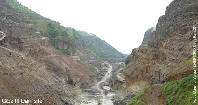
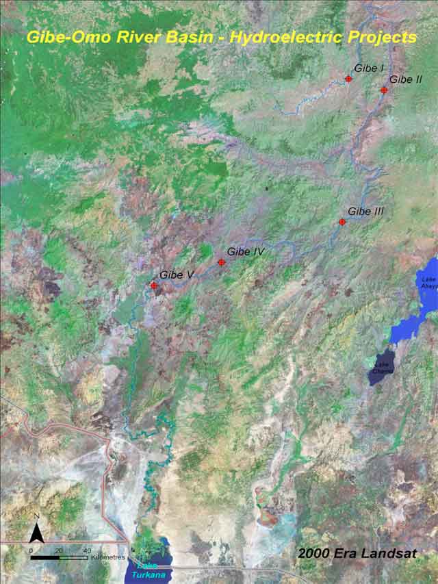
Figure 5: Map of Turkana basin north of Lake Turkana and the cascade of the Gibe reservoirs.
Full Size Image
The Gilgel Gibe I dam (Gibe I), the hydroelectric project with 184 MW capacity, was built in 2004 on the Gilgel Gibe River, a small tributary of
the main Gibe River, which flows into the main Omo River (Figure 5). Commissioned in 2010, the Gibe II hydroelectric plant channels the water already
impounded by the existing Gibe I hydroelectric plant through a 26-km long tunnel directly into the Gibe-Omo River. The resulting 500 m head is used to
generate 420 MW of electric power. As this project does not impound any water itself, it is assumed to have no substantial impact on Lake Turkana water levels.
The Gibe III dam is located on the Omo River around 150 km downstream of the Gibe II outlet. Near the dam, the area is characterised by a large plateau
with a long and relatively narrow canyon through which the river flows (The Gilgel Gibe Affair, 2008, Velpuri et. al., 2012, UNEP, 2013). Upon completion,
a 150-km dammed reservoir will be created, flooding the canyon from the dam upstream on the Gibe River, retaining about 14.7 billion m3 of water at maximum
capacity, which is equivalent to the total annual flows in Omo River. When construction of the Gibe III dam is completed, it will be the tallest dam in Africa.
It is estimated that the dam will be completed by the end of 2014 and possibly be operational by mid-2014. The mean annual inflow or discharge into the
reservoir is estimated to be 438 m3/s (13,800 million m3/year) with seasonal inflows varying from less than 60 m3/s in March to over 1,500 m3/s in August.
In terms of power generated, the capacity of Gibe III is around 8% of the capacity of the Three Gorges hydroelectric project in China (22,500 MW), the
largest in the world. Despite its smaller size/capacity with respect to the annual Omo River flows, there is a need to evaluate the likely environmental,
ecological, hydrological and social impacts of the Gibe III dam on downstream water resources within the Turkana basin to avoid and/or to mitigate any
adverse impacts. Once evaluated, suitable management strategies can be developed.
What are the findings?
Gibe III impact assessment on Lake Turkana water levels
Recently, UNEP published a report which is based on a study that used satellite-based data and a robust modeling approach to shed light on
some aspects of the hydrologic impact of Gibe III hydroelectric dam on Lake Turkana water levels (UNEP, 2013).
The focus of the UNEP study was to understand the impact of the Gibe III on Lake Turkana water levels using multi-source satellite data and
hydrologic and statistic modeling approaches. In this study, the impact assessment was performed beyond the first impoundment period. The
report also identified potential impacts of the dam under different future scenarios of rainfall using three different approaches: historical,
knowledge based and nonparametric resampling. This study incorporated the operational strategies for the Gibe III dam published by the Ethiopian
Electric Power Corporation. This study analysed average inflows into Lake Turkana using data from 19982009. The average rate of inflows into the
lake was found to be around 650 m3/s (wet season flow rate of more than 1,500 m3/s and dry season flow rate of 150 m3/s). During 19922010, Lake
Turkana's water level fluctuated between 360 m and 365 m above sea level. The potential impact of the Gibe III dam was assessed for a period of
12 years from the commencement of the dam using three different approaches; consistent results were obtained from all three. The key findings from this study are:
- The Gibe III reservoir would reach the Minimum Operational Level (MOL) of 201 m in 810 months. During this initial impoundment period,
it was found that the rate of inflow into Lake Turkana would be 42% of the average flow. This is because the area of Lake Turkana basin
upstream of Gibe III dam (catchment of Gibe III) contributes up to 58% of the Lake Turkana inflows. The total estimated impounded volume
of the Gibe III reservoir will be equal to 6% of the Lake Turkana volume.
- However, after the initial impoundment period, because of the Gibe III dam, the peak flows into the lake are reduced and dry season
flow was increased with a dam moderated average flow rate of 640 m3/s, which was only 10 m3/s less than average lake inflows without Gibe III.
- During the first impoundment period (8-10 months) Lake Turkana would lose an average of 1 m due to reduction in the lake inflows.
After the first impoundment period, Lake Turkana would lose up to 1.8 m over the 12-year analysis period.
- Based on the analysis of evapotranspiration data from 20012009, Gibe I and Gibe III would lose up to 1.34 m/yr and 1.46 m/yr of
water, respectively, due to evaporation. On the other hand, evaporation losses from Lake Turkana would account for up to 2.4 m/yr.
- Due to the regulation of lake inflows, the dam would have a greater impact when the basin receives above-normal rainfall
and a smaller impact when the basin receives below-normal rainfall.
- Changes in the shoreline or surface area are associated with the lake-level variations. This study identified 'hot spots'
of shoreline change, such as the Omo River Delta, Ferguson's Gulf and the TurkwelKerio River Deltas, which will show possible
shrinking and expansion due to construction of the Gibe III dam.
- This study indicated that under a below-normal rainfall scenario, the lake level would decline which could cause the lake shoreline
to recede up to 2 km along 'hot spot' areas. A normal rainfall scenario would result in minimal shoreline changes and an
above-normal rainfall scenario would expand the lake up to 3 km along the 'hot spot' areas.
- Based on the model simulation, the impact of the Gibe III dam on Lake Turkana water levels was found to be within the
natural variability of the lake observed since 1992.
This report (UNEP, 2013) also provides background information on hydroelectric projects in Africa, Gibe hydroelectric projects in
Ethiopia, climatic and physical factors in the Turkana basin that influence the lake levels and a detailed description of the
methodology used to model the potential impact of Gibe III on Lake Turkana water levels.
The use of satellite-based data to estimate runoff and evapotranspiration in this study made the modeling approach consistent and robust,
especially for a basin where long-term historical runoff and climate data are scarce. The results obtained under different scenarios would
be of great use to planners and others assessing the hydrological and environmental impacts of the dam under future climatic uncertainty.
However, this case study only considers the hydrologic impact of Gibe III dam on Lake Turkana water levels and does not include the
potential irrigation scenarios from the Omo River. This kind of in depth scientific analysis has not been done before. It provides
a starting point for commencement of further ground based studies on the lake and its environments. The impact of Gibe dams would
vary if additional developments, such as large scale irrigation, occurred, resulting in permanent removal of water from the Omo River.
What are the implications for policy?
Fader et al. (2013) reports that up to 1.3 billion people may be at risk of food insecurity by 2050 in present low-income economies
(mainly in Africa), if their economic development does not allow them to afford productivity increases, cropland expansion and/or imports
from other countries. Fader et al. (2013) further claim that it would only be possible to secure food security by cropland expansion, or by productivity improvements
in Africa. However, the key question to answer is How will African countries expand croplands or increase productivity unless they have
enough water storage capacity?' A way forward is to increase water availability through large and/or small dams. However, a comprehensive
assessment, which includes hydrological, ecological and economic factors, must be taken up for each project. In addition to such assessment
studies, transboundary water agreements must be considered by the respective governments.
In the Turkana basin, several research studies (Avery, 2010, 2012; Velpuri and Senay, 2012;UNEP, 2013) have indicated that the impact of
some of these dams (Gibe I or Gibe III) on Lake Turkana water levels would be minimal or within the natural variability of the lake if
water is only used for hydropower generation. However, these studies have also highlighted that the impact of the Gibe dams would vary
if additional developments (such as irrigation), which would result in permanent removal of water from Omo River are undertaken. Further
studies, which would include the assessment of eco-hydrological impacts of the dam, potential irrigation projects and accompanying
socioeconomic changes in the basin, should be carried out in collaboration with the Lake Turkana basin countries and stakeholders.
The need for a comprehensive environmental assessment of the impacts of the Gibe Dam has been already recognised by UNEP, the
riparian Governments and supported by the Ethiopian and Kenyan Governments.
Considering the future interests of Lake Turkana, the people within the Ethiopian and Kenyan areas of the Lake Turkana basin and
for the protection of the cradle of mankind the Lake Turkana region a transboundary water agreement to govern the use of Omo
River flows is needed. An agreement of this kind should provide a provision to regulate the permanent use of Omo River flows in
a way that the hydrologic and ecological impact of the dams or developmental projects are minimal while also ensuring protection
of the basin and benefitting the Lake Turkana basin communities in both Ethiopia and Kenya.
Acknowledgement
Synthesised by: Ashbindu Singha,b
(This bulletin is primarily based on the research work done by Naga Manohar Velpuri and Gabriel Senay).
Production and Outreach Team: Arshia Chandera, Erick Litswab, Kim Giesea, Lindsey Harrimana, Michelle Anthonya,
Reza Hussaina, Mwangi Theurib and Zinta Zommersb
Special thanks to Naga Manohar Velpuri and Gabriel Senay for their valuable inputs and, most importantly, for their extensive efforts to conduct this research.
Reviewed by: Djaheezah Subrattyc, Robert Wabunohad, Kaisa Uusimaab, Neeyati Patelb, Patrick M'mayib,
Peter Bjornsene, Ron Wittf and Andrea Salinasg
(a UNEP/GRID-Sioux Falls; b UNEP/DEWA-Nairobi; c UNEP/DTIE; d UNEP/DELC; e UNEP-DHI Centre; f UNEP/GRID-Geneva, g UNEP-ROLAC)
References
Amin, M., 1983. Cradle of mankind. Chatto and Windus Ltd., London.
Avery, S., 2010. Hydrological impacts of Ethiopia's Omo basin on Kenya's Lake Turkana water levels and Fisheries. The Africa Development Bank: Tunis, Nairobi.
Avery S., 2012. Lake Turkana and The Lower Omo: Hydrologic impacts of major dam and irrigation developments: Volume 1 Report. African Studies Centre, University of Oxford.
Bates, B., Kundzewicz, Z. , Wu, S., Palutikof, J. , 2008. Climate Change and Water, Technical Paper of the IPCC, IPCC Secretariat, Geneva.
Bartle, A., 2002. Hydropower potential and development activities. Energy Policy 30(14) , 1231-1239.
Butzer, K. , 1971. Recent history of an Ethiopian delta - The Omo River and the level of Lake Rudolf, Department of Geography, Research Paper No. 136. The University of Chicago Press Chicago.
Cerling, T., 1986. A mass-balance approach to basin sedimentation: Constraints on the recent history of the Turkana basin. Palaeogeography, Palaeoclimatology, Palaeoecology 54(1-4), 63 86.
Fader, M., Gerten, D., Krause, M., Lucht, W., Cramer, W. , 2013. Spatial decoupling of agricultural production and consumption: quantifying dependences of
countries on food imports due to domestic land and water constraints. Environmental Research Letters 8(1), 014046.
Kallqvist, T., Lien, L., Liti, D., 1998. Lake Turkana Limnological Study 1985 1988. Norwegian Institute of Water Resources, Report no. 0-85313.
Kaygusuz, K., 2004. Hydropower and the world's energy future. Energy Sources 26(3), 215-224.
Lautze, J., Giordano, M. and Borghese, M., 2005. Driving forces behind African transboundary water law: internal, external and implications.
International workshop on African Water Laws: Plural Legislative Frameworks for Rural Water Management in Africa, 26-28 January 2005, South Africa.
REN21, 2013. Renewable 2013 Global Status report, Renewable Energy Policy Network for the 21st Century.
Renewable Energy Policy Network for the 21st Century. www.ren21.net/REN21Activities/GlobalStatusReport.aspx (accessed 19.06.13).
Ricketts, R., Johnson, T., 1996. Climate change in the Turkana basin as deduced from a 4000 year long δO18 record. Earth and Planetary Science Letters 142 (1-2), 7-17.
The Gilgel Gibe Affair, 2008. An independent study about the Gilgel Gibe hydroelectric projects in Ethiopia
How states and corporations make business using the international public money, Publication of European Union.
The Economist, 2010. Tap that water: controversy surrounds the argument for dam-building in Africa.
The Economist, reprinted from print edition. http:// www.economist.com/node/16068950/ (accessed 19.06.13).
Velpuri, N., Senay, G., 2012. Assessing the potential hydrological impact of the Gibe III Dam on
Lake Turkana water level using multi-source satellite data. Hydrology and Earth System Sciences 16, 3561-3578, doi:10.5194/hess-16-3561-2012.
Velpuri, N., Senay, G., and Asante K., 2012. A multi-source satellite data approach for modelling Lake Turkana water level: calibration
and validation using satellite altimetry data, Hydrology and Earth System Sciences, 16:1-18.
UNEP, 2010. Africa Water Atlas. Division of Early Warning and Assessment (DEWA). United Nations Environment Programme, Nairobi.
UNEP, 2013. Ethiopia's Gibe III Dam: its Potential Impact on Lake Turkana Water Levels (A case study using hydrologic modelling and multi‑source
satellite data). Division of Early Warning and Assessment (DEWA), United Nations Environment Programme, February 2013.
WCD, 2000. Dams and Development A new framework for decision making, the report of the World Commission on Dams. Earthscan Publication Ltd., London and Sterling, VA.
Wolf, A., Natharius, J., Danielson, J., Ward, B., Pender, J., 1999. International River Basins of the World, International Journal of Water Resources Development 15(4), 387-427.
Yuretich, R., 1979. Modern sediments and sedimentary processes in Lake Rudolf (Lake Turkana) eastern Rift Valley, Kenya. Sedimentology 26(3), 313-331.
If you no longer wish to receive this bulletin you can unsubscribe anytime.
Information is regularly scanned, screened, filtered, carefully edited, and published for educational purposes. UNEP does not accept any liability
or responsibility for the accuracy, completeness, or any other quality of information and data published or linked to the site. Please read our
privacy policy and
disclaimer for further information.
|


