|
Having trouble reading this email?
Download the PDF.

Thematic focus: Climate change,
Ecosystem management, Environmental governance
A new eye in the sky: Eco-drones
A drone is generally thought of as a military weapon or surveillance tool. Commonly referred to as an unmanned aerial vehicle
(UAV), unmanned aerial system (UAS) or remotely piloted aircraft (RPA), a drone can also provide a low-cost and low-impact
solution to environmental managers working in a variety of ecosystems. Drones used for these purposes are referred
to as eco-drones or conservation drones. Their agility and quality imaging abilities make them advantageous as a
mapping tool for environmental monitoring, but there are still several challenges and concerns to be surmounted.
Why is this issue important?
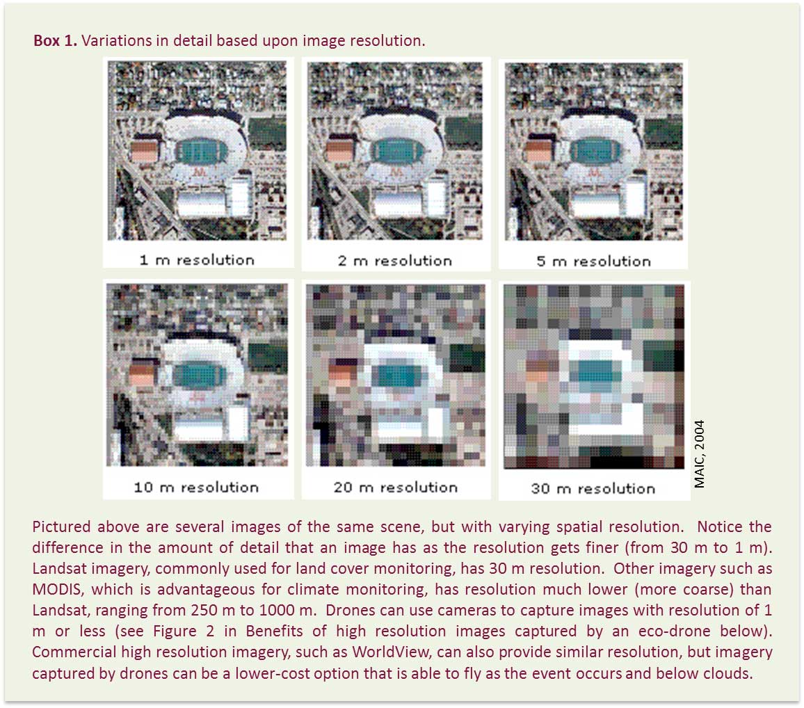
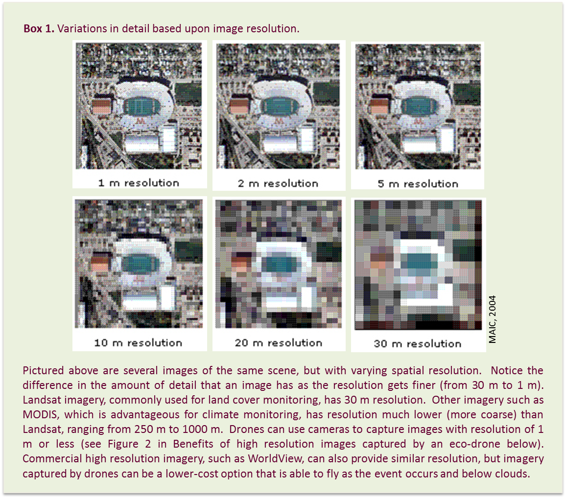
Although many types of satellite imagery are readily available low resolution for free online (Landsat, MODIS)
and high resolution for purchase (WorldView, Quickbird) they sometimes cannot offer sufficiently high resolution,
cover the specific area of study, or capture the time series necessary to fulfill the entire purpose of a project.
For several types of situations, satellite imagery and remote sensing analysis are the only way to see what has
occurred on the ground, but sometimes the information collected may not be adequate enough. If the image resolution
is not high enough to see exact areas of devastation or change, coverage of an entire affected area is not available,
or imagery is simply too expensive to acquire, then an analysis will be difficult to complete. The generally
low-cost high resolution image capture capability of eco-drones creates the potential for them to fill the data
gap between satellites and ground surveying in the aforementioned cases. In addition, eco-drones can do much
more than image acquisition, occasionally making them advantageous over typical satellite or aircraft image acquisition.
In addition to image capture, eco-drones can function as a real-time monitoring mechanism for disaster events or
illegal resource extraction, distribute broadcast messages and collect and transmit meteorological data (CielMap, 2012).
Drones can also fly in riskier and more treacherous areas than humans or manned aircraft can traverse, such as inaccessible
shorelines or hurricanes (Nagai et al., 2008, Watts et al., 2012, NOAA, 2012). Due to the size and aerodynamics of drones,
they are able to fly at lower altitudes, collecting more precise information than manned aircraft or satellites. This
also means that they can fly below clouds making them advantageous in tropical areas where clouds can often impede satellite
image collection. A typical UAS can capture images at about 6 cm spatial resolution when flying at an altitude slightly
over 200 m (Rango and Laliberte, 2010). With changing ecosystems and disaster dynamics caused by climate change and
urbanisation, as well as the elusive presence of environmental crime, on-demand aerial data collection and
real-time environmental monitoring will become increasingly important.
What are the findings?
A drone can be defined as a system with an aircraft with the capacity to fly semi or fully autonomously thanks to an onboard computer and sensors
(CielMap, 2012). Interest in using drones for scientific investigations dates back to the 1970s in which
developments during the Cold War created advantageous uses for drones in the research community (Watts et al., 2012).
Since then, billions of dollars have been poured into research and development of military and experimental drones,
alleviating the commercial market of much of these development costs and enabling the production of a low-cost product
that soon will be more widely available and lucrative to the civil and commercial markets (CielMap, 2012). Projections
for worldwide spending on unmanned aircraft, in all sectors, exceed US$89 billion over the next ten years
(Teal Group, 2012). Technology has improved tremendously over time, but still has far to go.
Full Size Image
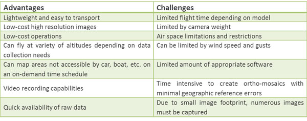
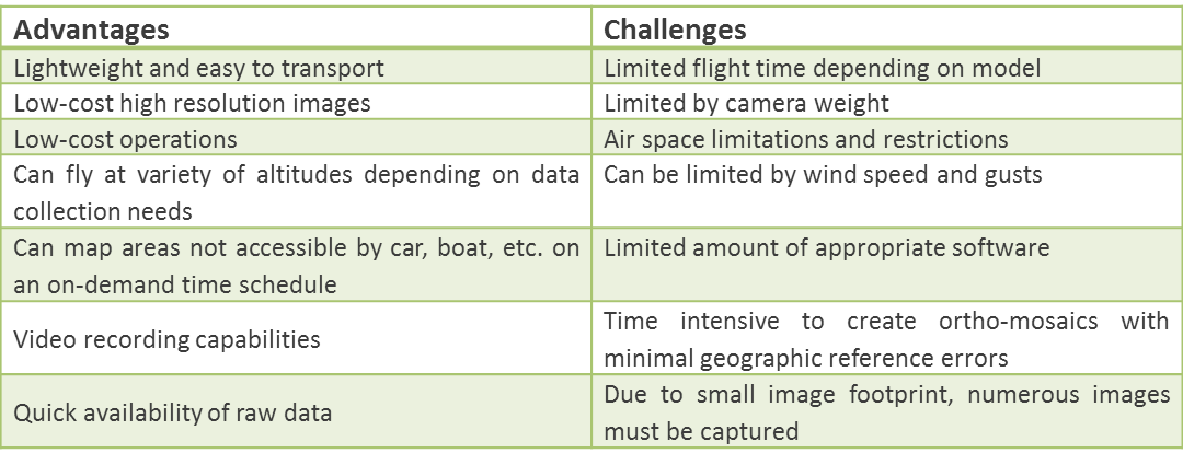
There are a few challenges associated with using drones, such as smaller image footprint (image area),
but with further technological exploration and field testing, solutions can be created. Table 1 describes
the advantages of using a drone as well as the challenges users and operators currently face.
Full Size Image
Table 1. Advantages and challenges associated with drones (Sources: Hardin and Hardin, 2010,
Niethammer et al., 2012, CielMap, 2012, Rango and Laliberte, 2010).
Components of the technology
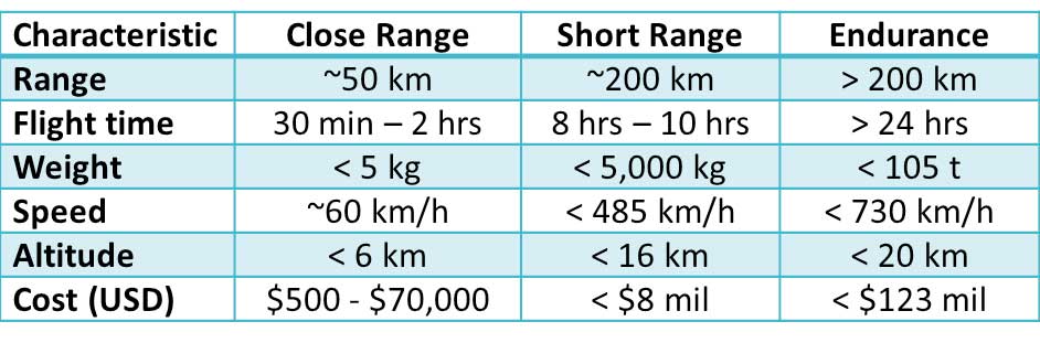
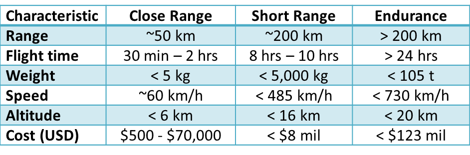
There are three general classes of drones, the most cost effective being close range, and several different
models of drones that vary in size, flight time, camera capability, takeoff and landing needs and altitude
flight level (Table 2). Drones can vary in wingspan from about 0.5 m to more than 35 m. Altitude is often
restricted by government regulations, but some small drones can fly as low as a few hundred metres and some
as high as 6,000 m. Large scale drones built for extreme endurance can fly as high as 20 km.
Full Size Image
Table 2. Characteristics of the three general classes of drones: close range, short range and endurance.
(Sources: Lucintel, 2011, Koh and Wich, 2012, CielMap, 2012); t = metric tonnes)
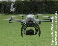
Different models of drones are advantageous for different applications. For example, a fixed wing unmanned
aircraft (Figure 1A) is best when an extended flight time is required over a long distance. If a small
area is being mapped, a multicopter (Figure 1B), which can remain stationary, is best to use.
Multicopters such as quad-rotors are also useful in areas of rugged terrain (Niethammer et al., 2012).
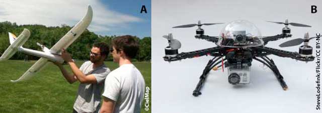
Figure 1. Types of unmanned aircrafts (drones). A. Fixed wing; B. Multicopter.
In addition to the drone itself, a complete unmanned aircraft system also refers to the ground control
station and the sensors on board (Watts et al., 2012). The complexity of the ground station varies depending
on the size of the drone (NOAA, n.d.). A small drone may only require a few laptops and an operator
on the ground, while a larger drone involves more equipment that may be mounted in vehicles or
trailers in the study area (Watts et al., 2012).
As the model of a drone varies, so does the type of camera or sensor used for image and information collection.
Standard imaging equipment on board consists of a digital camera and a multispectral sensor. Depending on how much
weight the drone can manage, additional types of sensors can also be carried onboard. Thermal infrared radiometres,
hyperspectral radiometres, Light Detecting and Ranging (LIDAR) instruments and Synthetic Aperture Radars (SAR) can
also be carried by drones (Rango and Laliberte, 2010). Images captured from a drone using these cameras and
sensors can be stitched together and given a geographical reference much like images from a satellite or a
manned plane can be (Hardin and Hardin, 2010).
As previously discussed, some types of drones are capable of carrying video cameras, meteorological
sensors, communication transmitters, or a combination of the three (CielMap, 2012). Drones equipped with
video cameras allow scientists to monitor disaster situations or biological phenomena such as migration
patterns in real time. Law enforcement officials monitoring remote sections of coastline or off-coast
areas for illegal fishing can also benefit from a drone with video capability. Meteorological
sensors can capture information such as wind, temperature, humidity and pressure (NOAA, 2012).
There are many dynamic uses for drones.
Benefits of high resolution images captured by an eco-drone
Niethammer et al. (2012) used drones with a high resolution camera to map fissures on the
Super-Sauze landslide in France that had never been mapped before with such detail. Each
fissure is approximately 0.1 m in width, making them impossible to detect or measure
using satellite data. Using drones enabled the researchers to detect changes in the
fissures and draw conclusions they would have had difficulty reaching from the use of
satellite imagery. Figure 2 shows a drone prototype and an image it took with a 12
megapixel (MP) camera. Future prototypes from CielMap will test 16 MP cameras
as well as a three band (RGB) sensor.
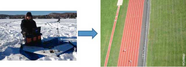
Figure 2. A prototype of a CielMap drone (left image) and a sample high resolution image (right image) taken with the 12 MP camera on board.
Full Size Image
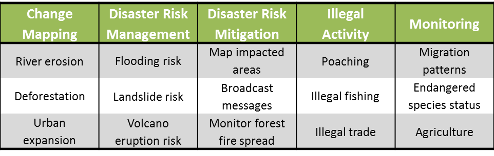
Innovative Field Applications
Eco-drones have the potential to supplement data collection efforts and contribute to
ecosystem inventory and accounting. Specific environmental and ecosystem applications
suitable for the use of a drone can range from precision agriculture, to mapping coastline
or soil erosion, to species and habitat monitoring. Drones can be launched into the eye
of a hurricane to measure windspeed at altitudes and conditions in which a manned aircraft
could not and they can fly over the Artic to observe sea ice conditions and track seal
populations (NOAA, 2008). One of the most common civil applications is rangeland
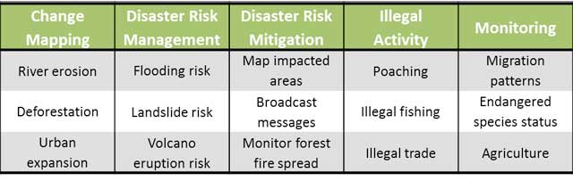
management (Rango and Laliberte, 2010). Other environmental applications are described in Table 3.
Full Size Image
Table 3. Various environmental applications suitable for the use of a drone.
Use of drones for monitoring destructive activities such as poaching and illegal logging
have been notably applied in Africa, Asia and South America. At the end of 2012, Google
awarded a US$5 million grant to the World Wildlife Fund (WWF) to use drones, alongside
other technologies, to monitor illicit trade in Africa by tracking poachers and the
wildlife they are pursuing. Referring to the technology as remote aerial survey
systems, surveys will be taken of susceptible areas in Africa and Asia where illegal trade
is a US$7 - $10 billion industry (WWF, 2012). Brazil has purchased 14 drones for US$350
million for the Sao Paul Environmental Police to monitor deforestation in the Amazon,
track poachers and seek out illegal mining operations (Cohen, 2011).
The growing occurrences of deforestation and forest degradation worldwide could be more
precisely monitored and measured with the use of drones. Member countries of
programmes such as the United Nations collaborative initiative on Reducing Emissions
from Deforestation and Forest Degradation in Developing Countries (REDD+) could benefit
from the monitoring capabilities of drones to measure and report deforestation, using the
data to calculate forest carbon emissions more accurately. The option of a low-cost
drone would be extremely beneficial to governments or organisations with small budgets
seeking to fulfill REDD+ requirements.
Early warning applications
Quick, easy deployment and ability to enter hazardous areas make drones a beneficial tool
for collecting real-time data about atmospheric conditions, mapping disaster impacts as
they occur and their aftermath. This information can be incorporated into current and
future early warning systems. Drones can provide information to emergency planners
by monitoring evacuation, identifying where environmental conditions are worsening
(i.e. flood spreading) and contribute to rescue efforts serving as an emergency
response mechanism.
Rapid urbanisation and road construction in China have led to increased frequency and
intensity of landslides along highways and roadways (Huang et al., 2011). With more
social and economic growth anticipated in China, more roads will be built. Therefore,
it is necessary for China to work towards mitigating disasters induced by road construction.
Drones can be used to monitor highways vulnerable to landslides, using high resolution
cameras to detect cracks that may indicate the onset of a landslide and sensors to detect
changes in stress. Once detected, data collected from the drone can be used by authorities
to initiate early warning allowing people currently in the area to escape and those
travelling to the area to avoid the disaster event before it occurs.
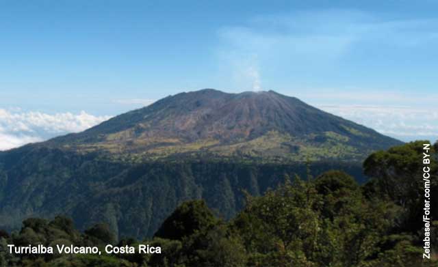
The National Aeronautics and Space Administration (NASA) recently flew a drone into the
sulfur dioxide plume and over the vent of the Turrialba Volcano in San Jose, Costa Rica
(pictured top) to collect data about its volcanic emissions (NASA, 2013).
Determining temperature, ash height and gas concentrations (such as sulfur dioxide)
over the vent can help scientists predict the direction of the volcanic plume.
Manned aircraft would not be able to collect this type of data because the engines would
ingest the ash emitted from the volcano, ruining the engines and proving the effort obsolete.
Information collected from these missions helps to reduce the impact of potential environmental
hazards such as volcanic smog (sulfur dioxide), which can be harmful to people living
near the volcano and can eventually be used for early warning.
The use of drones for early warning of forest fires has been tested by several federal
agencies in the USA. By collecting data about forest fires, the public can be alerted
of impending danger and firefighters can better plan for how to attack the fires. While
helicopters and manned planes could collect similar information, pilot projects conducted
by the United States Forest Service (USFS) have proven that UAS technology has a place in
wildland fire-fighting especially when considering flight costs, contract requirements,
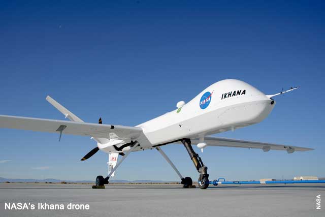
regulations and operations (Hinkley and Zajkowski, 2011). The United States Department
of Agriculture (USDA) and NASA have used a drone named Ikhana (pictured above) to
gather information that helps fight raging forest fires in California, USA (NASA, 2010).
Ikhana has a wingspan of about 20 m, is 11 m in length and can carry more than 180 kg
of sensors internally and over 900 kg in pods under its wings. It is designed for
long endurance flights at higher altitudes, typically flying at an altitude of 12 km,
allowing it to gather a significant amount of data over a long period of time and
at an altitude high enough to stay out of the heat of the fires (NASA, 2007).
Ikhana is also being used to test new capabilities and advance its technological
capabilites to improve the design and function of drones.
What are the implications for policy?
As UAVs become more prevalent in the public and private sectors for research and
non-military surveillance, many policy considerations will need to be made. According
to a 2012 United States Government Accountability Office (GAO) report, the number of
countries with a UAV system for military, commercial, or civil use grew from 41 countries
in 2004 to 76 countries by 2011 (GAO, 2012). Tremendous cooperation between nations in
regards to airspace jurisdiction will be necessary in the future as eco-drones, and other
research drones, become more commonplace. Policy creation and enforcement for demarcation
of eco-drones is necessary for communicating to people on the ground that the drones are safe,
only for research and to be clearly visible to other air traffic. Future regulations will
need to address weight and size of the drones. Data sharing standards will need to be
created if data is collected in airspace not native to the research team. Regulations
specific to drones used for environmental modeling or research will need to be developed,
implemented and enforced with heavy regard to public safety and privacy (Rango and Laliberte, 2010).
Currently, within American airspace, some universities and research establishments in the public
and private sector are able to fly drones for purposes that appeal to public interests, such as
disaster relief, search and rescue and border patrol (FAA, 2013). To fly a drone, the public sector
must obtain a Certificate of Waiver or Authorisation (COA) and the private sector must obtain an
experimental airworthiness certificate in addition to following many regulations (FAA, 2013). For
both sectors, drones may not be flown over densely populated areas to ensure public safety.
For the USA, a better understanding of the systems, operations and technology will be gained
over the next few years as the Federal Aviation Administration (FAA) works towards fully
integrating UASs into the National Airspace System (NAS) by 2015 (FAA, 2012).
On a global scale, UAV manufacturing and export as well as licensing will need to be
regulated to ensure that purpose remains ethical and legitimate and does not violate
public safety and privacy (GAO, 2012). European regulations generally coincide with
those of the USA, but requirements among most other countries vary considerably (Watts et al., 2012).
Full Size Image
Acknowledgement
Written by: Lindsey Harrimana and Joseph Muhlhausenb.
Production and Outreach Team: Arshia Chanderb, Erick Litswaa, Kim Gieseb, Lindsey Harrimanb,
Michelle Anthonyb, Reza Hussainb, Mwangi Theuria and Zinta Zommersa
Special thanks to Ashbindu Singha,c, Arshia Chandera, Zinta Zommersc, Andrea Salinasd and Shelley Robertsone
for their valuable inputs and review and to the USGS-UASPO for their photo contribution.
(a UNEP/GRID-Sioux Falls; b CielMap; c UNEP/DEWA-Nairobi; d UNEP/DEWA-LAC; e University of Toronto,
Munk School of Global Affairs)
References
CielMap, 2012. Low-Cost Unmanned Aircraft Systems for Development Projects: A quiet revolution. Presentation, Sciences Po Paris.
Cohen, M.J., 2011. Brazilian Eyes in the Sky Focus on the Disappearing Rainforest. Scientific American.
http://www.scientificamerican.com/article.cfm?id=brazilian-eyes-in-the-sky-focus-on-2011-10 (accessed 25.04.2013).
FAA, 2012. FAA Makes Progress with UAS Integration. Federal Aviation Administration.
http://www.faa.gov/news/updates/?newsId=68004 (accessed 18.04.2013).
FAA, 2013. Fact Sheet Unmanned Aircraft Systems (UAS). Federal Aviation Administration.
http://www.faa.gov/news/fact_sheets/news_story.cfm?newsId=14153 (accessed 18.04.2013).
GAO, 2012. Agencies Could Improve Information Sharing and End-Use Monitoring on Unmanned Aerial Vehicle Exports. United States Government Accountability Office.
Available online: http://www.gao.gov/assets/600/593131.pdf.
Hardin, P.J. and Hardin, T.J., 2010. Small-scale remotely piloted vehicles in environmental research. Geography Compass. 4(9), 1297-1311.
Hinkley, E.A. and Zajkowski, T., 2011. USDA forest service NASA: unmanned aerial systems demonstrations pushing the
leading edge in fire mapping. Geocarto International. 26(2), 103 11.
Huang, Y., Yi, S., Li, Z., Shao, S., Qin, X., 2011. Design of highway landslide warning and emergency response systems based on
UAV. Proc. SPIE 8203, Remote Sensing of the Environment: The 17th China Conference on Remote Sensing, 820317.
http://dx.doi.org/10.1117/12.910424.
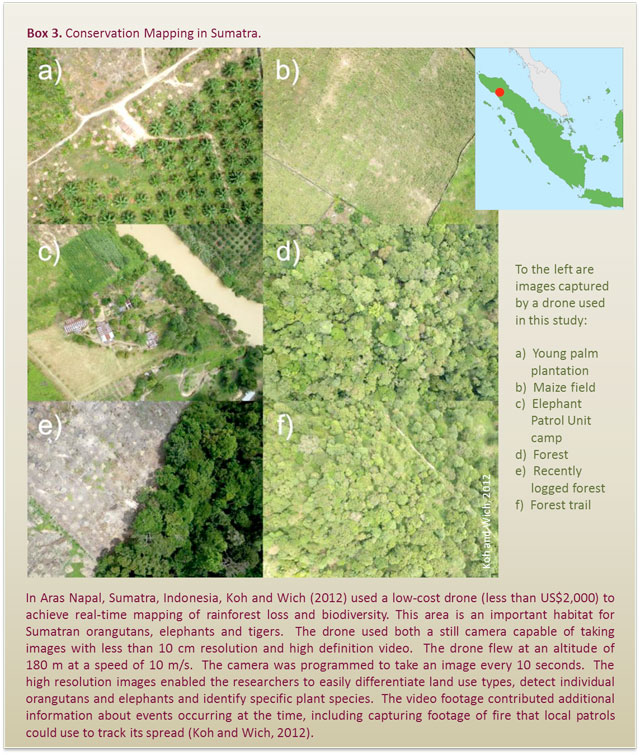
Koh, L.P. and Wich, S.A., 2012. Dawn of drone ecology: low-cost autonomous aerial vehicles for conservation.
Tropical Conservation Science. 5(2), 121-132. Available online: www.tropicalconservationscience.org.
Lucintel, 2011. Growth Opportunity in Global UAV Market. Lucintel Brief. Available online:
http://www.lucintel.com/LucintelBrief/UAVMarketOpportunity.pdf.
MAIC, 2004. Remote Sensing Resolution. Mine Action Information Center Spatial Information Clearinghouse.
http://maic.jmu.edu/sic/rs/resolution.htm (accessed 21.04.2013).
Nagai, M., Chen, T., Ahmed, A., Shibasaki, R., 2008. UAV Borne Mapping by Multi Sensor Integration. The International Archives of the
Photogrammetry, Remote Sensing and Spatial Information Sciences. Vol. XXXVII. Part B1. Beijing. pp. 1215-1222.
NASA, 2007. Ikhana Unmanned Science and Research Aircraft System. National Aeronautics and Space Administration.
http://www.nasa.gov/centers/dryden/news/FactSheets/FS-097-DFRC.html
(accessed 19.04.2013).
NASA, 2010. NASAs Ikhana Aircraft Helps Fight 1,000+ California Fires. National Aeronautics and Space Administration.
http://www.nasa.gov/offices/ipp/centers/dfrc/news_events/SS-Ikhana.html (accessed 18.04.2013).
NASA, 2013. NASA flies Dragon Eye unmanned aircraft into volcanic plume. National Aeronautics and Space Administration.
http://climate.nasa.gov/news/891 (accessed 19.04.2013).
Niethammer, U., James, M.R., Rothmund, S., Travelletti, J., Joswig, M., 2012. UAV-based remote sensing of
the Super-Sauze landslide: Evaluation and results. Engineering Geology. 128, 2-11.
NOAA, n.d. NOAA Unmanned Aircraft Systems Program. National Oceanic and Atmospheric Administration.
http://uas.noaa.gov/(accessed 18.04.2013).
NOAA, 2008. NOAA Invests $3 Million for Unmanned Aircraft System Testing Pilotless Craft Gather Data for Hurricane Forecasts,
Climate, West Coast Flood Warnings. National Oceanic and Atmospheric Administration.
http://www.esrl.noaa.gov/news/2008/uas.html (accessed 18.04.2013).
NOAA, 2012. NOAA Scientists Part of NASA-Led Mission to Study the Damaging Storms with Unmanned Aircraft, New Instruments.
National Oceanic and Atmospheric Administration.
http://uas.noaa.gov/news/target-hurricanes.html(accessed 19.04.2013).
Rango, A. and Laliberte, A., 2010. Impact of flight regulations on effective use of
unmanned aircraft systems for natural resources applications. Journal of Applied Remote Sensing. 4(1).
Teal Group, 2012. Teal Group Predicts Worldwide UAV Market Will Total $89 Billion in its 2012 UAV
Market Profile and Forecast. Teal Group Corporation.
http://tealgroup.co/index.php/ (accessed 19.04.2013).
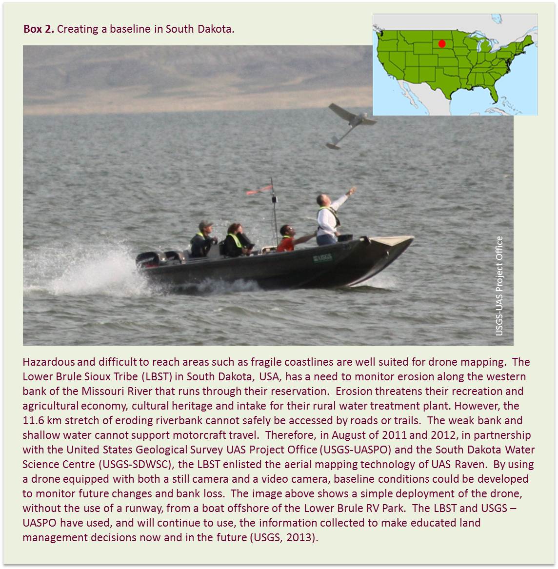
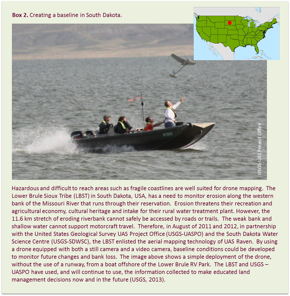
USGS, 2013. UAS Raven flight operations to monitor bank erosion on the Lower Brule Reservation in South Dakota. United States Geological Society.
http://rmgsc.cr.usgs.gov/UAS/missouriRiverErosion.shtml (accessed 18.04.2013).
Watts, A.C., Ambrosia, V.G., Hinkley, E.A., 2012. Unmanned Aircraft Systems in Remote Sensing and Scientific Research:
Classification and Considerations of Use. Remote Sensing. 4(6), 1671 1692.
WWF, 2012. Google Helps WWF Stop Wildlife Crime. World Wildlife Fund.
http://worldwildlife.org/stories/google-helps-wwf-stop-wildlife-crime?utm_source=twitter.com (accessed 18.04.2013).
If you no longer wish to receive this bulletin you can unsubscribe anytime.
Information is regularly scanned, screened, filtered, carefully edited, and published for educational purposes. UNEP does not accept any liability
or responsibility for the accuracy, completeness, or any other quality of information and data published or linked to the site. Please read our
privacy policy and
disclaimer for further information.
|
