|
Having trouble reading this email? Download the PDF. 
Thematic Focus: Climate Change, Ecosystem ManagementAfrica without glaciersWhy is this issue important? Glaciers are a critical component of the earth' system and the current accelerated melting and retreat of glaciers have severe impacts on the environment and human well-being, including vegetation patterns, economic livelihoods, natural disasters, sea level fluctuations and the water and energy supply (UNEP 2008).Glaciers are one source of the planet's freshwater; they store and release it seasonally, replenishing the rivers and groundwaters that provide people and ecosystems with life sustaining water. Declining glacier melt will affect agriculture, domestic supplies, hydroelectricity and industry in the lowlands and cities far from the mountains (UNEP 2007). Glaciers' decline also often has an impact in the tourism sector, not to mention the general aesthetic/visual value they provide. 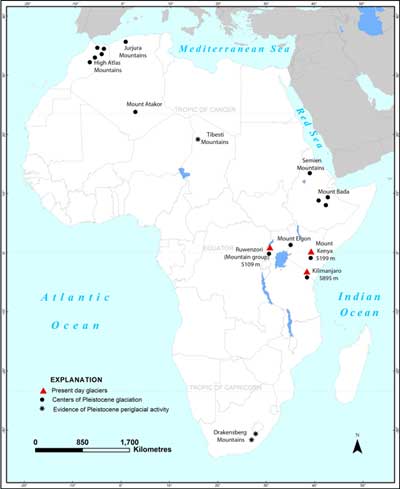
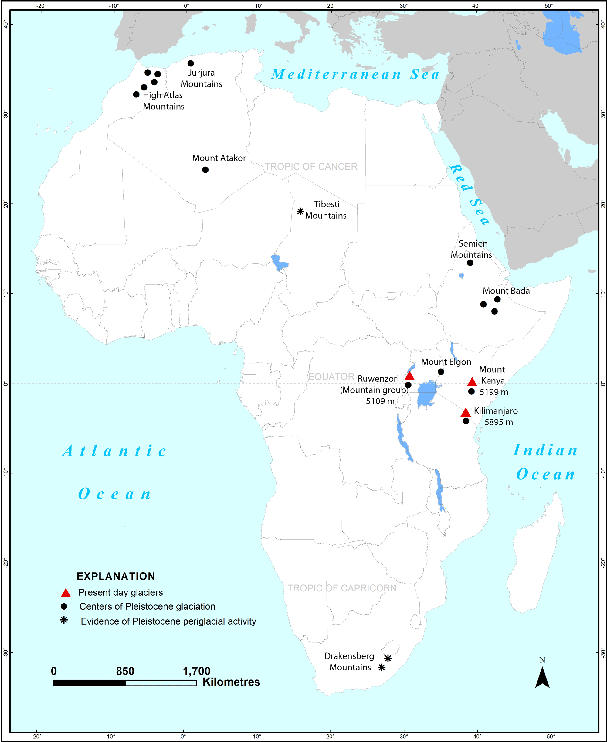
Figure 1: Location of Africa's present-day glaciers, marked with solid red triangles. Redrawn from Young and Hastenrath 1991 Surprisingly, there are a number of glaciers in Africa. They are all located in East Africa near the equator, and since 1900, have lost over 80 per cent of their surface area (Russell and others 2009) (Figure 1). They sit atop the volcanic mountains of Mount Kenya in Kenya and Mount Kilimanjaro in Tanzania, and on the Ruwenzori range in Uganda and the Democratic Republic of Congo (DRC). At the end of the 1990s, these glaciers had a total area of about 10.7 km˛ (Young and Hastenrath 1991). These mountains' flanks are covered with a great range of vegetation types according to the vast vertical differences in altitude and rainfall. For example, the eight ecological zones on the slopes of Mount Kenya range from a cultivated zone below 1 800 m to the Afro-alpine zone (areas above 3 500 to 3 800 m) found above most vegetation (UNEP 2009). Mount Kilimanjaro is 5 895 m high and is located in northern Tanzania 300 km south of the equator. It is the highest mountain in Africa and the world's highest free-standing mountain. It consists of three volcanoes: Kibo, Mawenzi, and Shira. With its ice-cap gleaming under the tropical sun atop its iconic bulk that emerges from the flat plain, it is one of the world's most easily recognized mountains. The 16 named glaciers and 3 ice fields are arranged around the Kibo caldera, while the mountain is relatively undissected and has a 95-km-long by 65-km-wide base (Young and Hastenrath 1991, Frömming 2009). 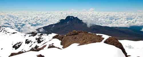
Mt. Kilimanjaro. Photo: Weixiang Ng/ Flickr Some 1.5 million people live around Mount Kilimanjaro, of which nearly three quarters depend on its rich natural resources for their livelihoods, including farming the fertile volcanic soils (Misana and others 2012). Many are employed in the mountain's busy tourism industry that sees more than 35 000 climbers a year, plus 5 000 day visitors (Mitchell and others 2009) and is one of Tanzania's most important economic sectors (Frömming 2009). Mount Kenya straddles the equator, 193 km northeast of Nairobi and about 480 km from the Kenyan coast (UNESCO n.d.). Its snow-capped peak rises dramatically above the savannah and its silhouette is an iconic symbol of Kenya recognized around the world (UNEP 2009). At 5 199 m, the mountain is Africa's second-highest. It is the remnant of a large volcano and its diameter from north-to-south is 100 km, which is just slightly larger than its west-to-east axis. Its ice cap is composed of 10 glaciers that occupy the valleys of this very dissected mountain (UNEP 2007). The mountain attracts thousands of climbers every year and in 2009, some 25 000 people visited Mount Kenya National Park (Government of Kenya 2010). In addition to its beauty and contribution to the country's tourism industry, Mt. Kenya is valuable for timber, farmland, and tourism and its forested slopes are a critical water catchment, acting as "water towers" for much of the country (UNEP 2009). The Ruwenzori massif at 5 109 m is popularly called the "Mountains of the Moon". It is a 50-km-wide block of mountains that rises between two faults in the earth's crust. It straddles the Uganda-DRC border and has a total area of 3 000 km2 (Russell and others 2009). The range is heavily dissected into valleys and individual mountains that run about 100 km northwestwards from the Equator. The range's central portion contains 25 peaks over 4 500 m, the highest of which is the Margherita peak on Mount Stanley, which exceeds 5 000 m (Young and Hastenrath 1991). The Ruwenzori glaciers occur on only three of the range's peaks: Mounts Stanley, Speke and Baker (Klein and Kincaid 2007). In the early 1990s, the total glaciated area was about 5 km2 (Young and Hastenrath 1991). Their forested slopes are important water sources for the lower plains. What are the findings? UNEP's Global Outlook for Ice and Snow (UNEP 2007) reports that "with few exceptions, all the alpine glaciers of the world are losing mass and it is predicted that this trend will continue as global warming progresses". Monitoring of mass ice budgets and surface topography has taken place on Mount Kenya for decades, especially on Lewis Glacier, while less is known about trends in ice thickness on Kilimanjaro (Hastenrath 2010) and even less about the Ruwenzori glaciers (Vidal 2012). There is scientific evidence that during the Pleistocene Epoch (some 2.5 to 11 million years ago), the east African mountain glaciers covered several hundred square kilometres (Young and Hastenrath 1991). Africa's glaciers began to recede in the 1880s and between 1906 and 2006, they lost about 82 per cent of their area and the larger glaciers became fragmented (UNEP 2007, Hastenrath 2010).
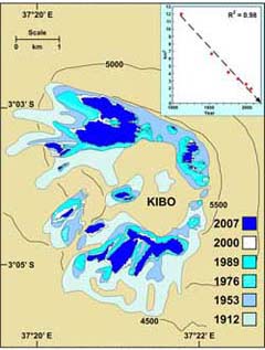
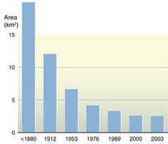
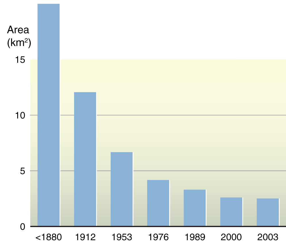
The ice cover on Kilimanjaro's Kibo glacier has been mapped intermittently since 1912 (Figure 2). Since then, research by Thompson and others (2009) shows that 85 per cent has disappeared and 26 per cent of the ice that remained in 2000 was gone by 2009. Between 2000 and 2009, the Furtwängler Glacier thinned by about half at the research site, and ice volume on two ice fields thinned or shrank by nearly the same volume between 2000 and 2007 (Thompson and others 2009).
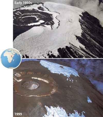
Figure 5: Satellite images from 1976 and 2006 showing the decline of Kilimanjaro's glaciers (UNEP n.d.). Mount Kenya Only 10 of the 18 glaciers that covered Mount Kenya's summit a century ago remain, leaving less than one third of the previous ice cover. The ice on Mount Kenya has also become thinner. Emerging evidence suggests the decline has accelerated since the 1970s (UNEP 2009) (Figures 6, 7 and 8). 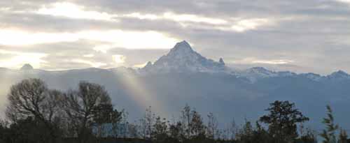
Mt. Kenya. Photo: Chris Hutchins/Flickr
Figure 6: Satellite images of Mount Kenya's glaciers, 1976 (UNEP n.d.) and 2012.
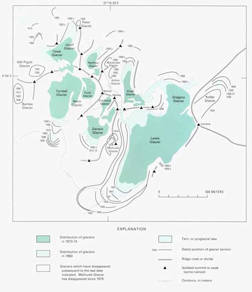
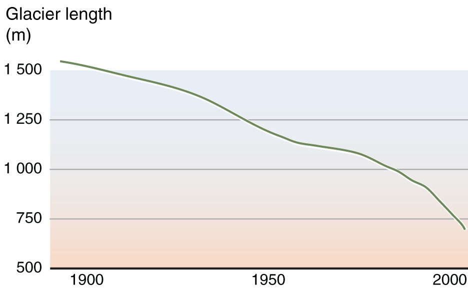
Figure 7: Mount Kenya's shrinking glaciers. Source: Young and Hastenrath 1991 By 2010, Lewis Glacier, the largest on Mt. Kenya had decreased by 90% in its volume (area) since 1934. The highest rates of ice volume loss occurred around the turn of the century (Prinz and others 2011). 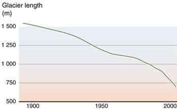
Figure 8: Ice loss on Lewis Glacier, 1900s to 2000s. Source: UNEP 2007 The Ruwenzori Range Perpetual clouds over the Ruwenzori range make it difficult to monitor trends in ice cover through aerial or satellite photography (Vidal 2012). In addition, few researchers have visited the glaciers for field studies (Klein and Kincaid 2007). On one visit in 1974, it was estimated that since 1958, the Speke Glacier had retreated by 30 to 40 m and shrunk laterally by 10 to 20 m (Young and Hastenrath 1991).
Figure 9: Satellite images of the Ruwenzori, 1995 (UNEP n.d.) and 2012. Klein and Kincaid (2007) used a combination of images of the Ruwenzori glaciers to determine the area of ice between 1987 and 2006 and found it had decreased by about 50 per cent (from 2.55 km2 to 1.31 km2), although uncertainties remain. Satellite images taken in 1995 and in 2012 (Figure 9) show a decline in the extent of the glaciers on these mountain peaks. A century ago the glaciers of the Ruwenzori Mountains covered nearly 6.5 km2. If they continue to recede, as they have since 1906, some experts project that they would be gone in coming decades (UNEP n.d., Barry 2006). Why are the glaciers retreating? The dramatic shrinking of Kilimanjaro's glaciers has attracted global attention (Thompson and others 2009). In the popular mind, it has come to represent the impacts of climate change. Variations in many conditions can influence glacial melt, however, including precipitation, temperature, cloud cover, direct evaporation from the glacier surface and the mountain's relief (Young and Hastenrath 1991). The glacial loss on East Africa's mountains beginning in the 1880s is thought to have been due to declining precipitation and less cloudiness leading to higher solar radiation. Then in the 20th century, the relative role of higher temperatures occurring over the past decades began to be a matter of debate (Young and Hastenrath 1991) (UNEP 2007). For example, Kaser and others (2010) affirm that the primary driver of changes to Mount Kilimanjaro's Kibo glacier over the past 120 years is atmospheric moisture rather than rising local air temperature (Kaser and others 2010). On the other hand, Thompson and others (2009) confirm that warmer conditions near the surface as well as higher temperatures in lower latitudes play important roles in the disappearing ice while noting that the lack of temperature records on Kilimanjaro's peak and the recent and short time span of satellite observations create some uncertainty. 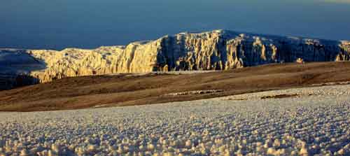
Mt. Kilimanjaro. Photo: Abir Anwar/Flickr Studies of the Lewis Glacier on Mount Kenya found that higher temperatures during the 1900s were a greater cause of its shrinking than sun exposure (Campbell 2008). Hastenrath (2010) contends that some warming during the 20th century and associated rises in atmospheric humidity, along with a possible contribution of continued solar radiation forcing are the causes of Mount Kenya's recent ice losses. The glacial recession on the Ruwenzori Mountains is most likely because of higher air temperatures and less snow accumulation during the 20th century (UNEP n.d.), in contrast to the lack of rainfall thought to play an important role on Mount Kilimanjaro (Vidal 2012). It is also possible that decreasing cloud cover over the same time period has contributed to vaporization of these glaciers (UNEP n.d.). What are the implications? In the current scenarios of climate change, the ongoing trend of worldwide and rapid, if not accelerating, glacier shrinkage on the century time scale may lead to the deglaciation of large parts of many mountain ranges in the coming decades (UNEP 2008). Regardless of the relative contributions the different causes make to the shrinking glaciers, if present climatic conditions continue, the African glaciers will disappear within several decades, in concert with the retreat of most tropical glaciers throughout the world (Thompson and others 2009). In mountainous regions where glacial melt contributes to river flows, climate change will significantly affect associated aquatic ecosystems and the human activities dependent on them. At first, meltwater inputs will increase river runoff, but then there will be a sharp decline (UNEP 2007). In Africa, however, the shrinking glaciers will have little impact on water resources because glaciers provide modest, if any, water to lower elevation streams, as most ice is lost through sublimation; water from the small amount of melting evaporates very quickly (UNEP 2009). The major effects of the shrinking of these iconic glaciers will be the loss of ice that is part of the attraction to tourists, awed by the beauty of the white-topped mountains in their flat arid landscapes, the novelty of snow near the equator and the last opportunity to see the glaciers before they are gone (Campbell 2008). Africa contributes very little to global greenhouse gas emissions considered a key driver of climate change, but it is highly vulnerable to the impacts. Glacier loss is likely to mean the loss of tourism revenues that are so vitally important to the economies of Kenya and Tanzania especially. Policies will need to address how to adapt to these impacts, at the same time as they promote economic development without increasing fossil fuel dependency and using inefficient technologies. Acknowledgement Written by: Jane Barra, Arshia Chanderb
References Barry, R. (2006). The status of research on glaciers and global glacier recession: a review. Progress in Physical Geography. July 2006 vol. 30 no. 3 285-306. doi: 10.1191/0309133306pp478ra. http://ppg.sagepub.com/content/30/3/285.full.pdf+html (accessed on August 15, 2012). Campbell, R. (2008). Mount Kilimanjaro, Tanzania: 1976, 2000. U.S. Geological Survey. 2008. http://earthshots.usgs.gov (accessed on August 10, 2012). Cullen, N., T. Mölg, G. Kaser, K. Hussein, K. Steffen, Hardy, D. (2006). Kilimanjaro Glaciers: Recent areal extent from satellite data and new interpretation of observed 20th century retreat rates, Geophysical Research Letters, 33, L16502, doi:10.1029/2006GL027084. Frömming, U. (2009). "Kilimanjaro's melting glaciers: on the colonial and postcolonial perception and appropriation of African nature." Etnográfica [online] 13, no. 2 (2009): Available at: http://etnografica.revues.org/1158. Government of Kenya. (2010). Tourism Performance Overview 2010. http://www.tourism.go.ke/ministry.nsf/pages/facts_figures (accessed on August 11, 2012). Hastenrath. S. (2010). Climatic forcing of glacier thinning on the mountains of East Africa. International Journal of Climatology 30: 146–152, doi: 10.1002/joc.1866. Kaser, G., Mölg, T., Cullen, N., Hardy, D., Winkler, M. (2010). "Is the decline of ice on Kilimanjaro unprecedented in the Holocene?" The Holocene 20, no. 7 (2010): 1079-1091. Klein, A., and Kincaid, J. (2007). "A Reassessment of the Satellite Record of Glacier Change in the Rwenzori Mountains, East Africa." 64th Eastern Snow Conference, St. John's, Newfoundland, Canada. 2007. Misana S, Sokoni C., Mbonile M.(2012). Land-use/cover changes and their drivers on the slopes of Mount Kilimanjaro, Tanzania. Journal of Geography and Regional Planning Vol. 5(6), (2012) pp. 151-164. Mitchell, M., Keane, J., Laidlaw, J. (2009).‘ Making success work for the poor: Package tourism in Northern Tanzania.' 16 January, 2009. SNV. http://www.odi.org.uk/resources/docs/4203.pdf (accessed on August 14, 2012). Prinz, R., Fischer, A., Nicholson, L., Kaser, G. (2011). Seventy-six years of mean mass balance rates derived from recent and re-evaluated ice volume measurements on tropical Lewis Glacier, Mount Kenya, Geophys. Res. Lett., 38, L20502, doi:10.1029/2011GL049208. Russell, J., Eggermont, H., Taylor, R., Verschuren D. (2009). Paleolimnological records of recent glacier recession in the Rwenzori Mountains, Uganda-D. R. Congo. J Paleolimnology (2009) Volume 41, Issue 2, pp 253-271. Thompson, L.G., H.H. Brechera, E. Mosley-Thompson, D.R. Hardy, and B.G. Mark. (2009). "Glacier loss on Kilimanjaro continues unabated." (Proceedings of the National Academy of Sciences (PNAS)) 106, no. 47 (2009): 19770–5. UNEP. (no date). Atlas Hotspots. http://na.unep.net/atlas/webatlas.php?id=270 (accessed on July 22, 2012). UNEP. (2005). One Planet, Many People: Atlas of Environmental Change. Nairobi: United Nations Environment Programme. UNEP. (2007). Global Outlook for Ice and Snow. Nairobi: UNEP/GRID-Arendal, 2007, Available at: http://www.unep.org/geo/geo_ice/. (accessed on July 22, 2012). UNEP. (2009). Kenya: Atlas of Our Changing Environment. Nairobi: United Nations Environment Programme. UNESCO (n.d.). Mount Kenya National Park/Natural Forest. n.d. http://whc.unesco.org/en/list/800/ (accessed on August 10, 2012). Vidal, J. (2012). "Race to Map Africa's Forgotten Glaciers Before They Melt Away." The Guardian, 3 June 2012: Available at: http://www.guardian.co.uk/environment/2012/jun/03/melting-glaciers-rwenzori-uganda-congo. Young, J. and Hastenrath, S. (1991). "Glaciers of the Middle East and Africa - Glaciers of Africa ." In Satellite Image Atlas of Glaciers of the World, edited by R.S. Jr. Williams and Jane G. Ferrigno. U.S. Geological Survery Professional Paper 1386-G-3 , 1991.
If you no longer wish to receive this bulletin you can unsubscribe anytime. Information is regularly scanned, screened, filtered, carefully edited, and published for educational purposes. UNEP does not accept any liability or responsibility for the accuracy, completeness, or any other quality of information and data published or linked to the site. Please read our privacy policy and disclaimer for further information. |


